Record-Breaking Night of Bird Migration Caught on Radar During a ‘Perfect Storm’ for Feathered Flight

BirdCast

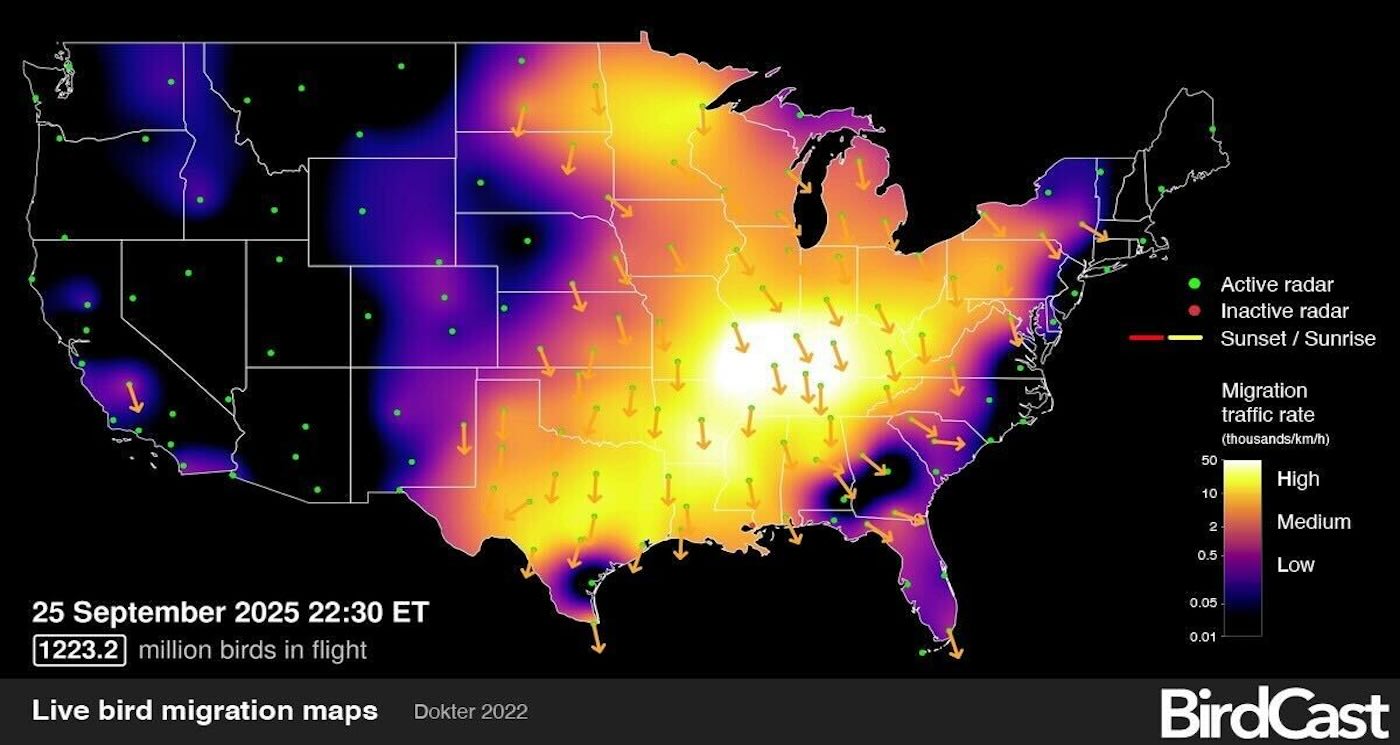
More than 1.2 billion birds streamed south in one night during their Fall migration in late September—the largest single-night total ever recorded by the American live radar project.

Called BirdCast, a collaboration led by the Cornell Lab of Ornithology, the platform uses the same weather radar technology behind daily forecasts to track migrating birds.

On its live migration map, BirdCast tracked more than 1.2 billion birds streaming toward their wintering grounds after sunset on September 25—the largest single-night total recorded since the project began mapping live migrations in 2018.

“These numbers are almost inconceivable,” said Andrew Farnsworth, a visiting scientist at the Cornell Lab of Ornithology and longtime BirdCast researcher. “They’re enormous… even for people that study migration regularly. The scale of how many organisms that this represents, is just mind blowing.”

The surge surpasses the previous milestone of one billion birds, first observed during the migration in October 2023. Both included well over one hundred species flying toward warmer weather, including songbirds and shorebirds.

Farnsworth said this seemingly rare night captured about 10% of the continent’s birds in flight at the same time. On an average fall night during peak migration, about 400 million birds are detected in flight at the same time above the United States, but on this night, the number was three times that.

“It’s really unbelievable,” he said.

While astonishing to both birders and scientists, Farnsworth said this event was not random. It resulted from a combination of ideal migrating conditions coinciding with the peak of fall migration.

The weather that night was perfect for travel, he explained in a media release. It featured calm winds—including tail winds that helped push the birds along their migratory paths across much of the center of the country and the Mississippi River valley.

Farnsworth said this record-breaking migration—documented by radar technology that was never intended to track birds—is a chance to not only to marvel at the immense magnitude of bird migration but also a chance to remind the public that the data is freely available and accessible in real time.

The technology at BirdCast.org allows anyone to view forecast maps that predict the number of birds migrating while live migration maps show migration happening in real time. Both tools let people know when birds are moving nearby, so they can take necessary precautions to protect them.

“BirdCast gives the ability for more people to engage in and participate in this incredible spectacle,” Farnsworth said, whose Cornell Lab partners with three US universities in the project: Purdue, Illinois Urbana-Champaign, and Massachusetts Amherst.

It’s also a timely reminder that you can help make birds’ journeys safer. Every year, more than one billion birds die in collisions with windows in the United States.

Bright lights can disorient birds migrating at night, drawing them into areas where collisions with glass are common. To assist our feathered friends, turn off nonessential lights at night. You can also add bird friendly film or other markings on the outside of windows. Learn more at stopbirdcollisions.org. Record-Breaking Night of Bird Migration Caught on Radar During a ‘Perfect Storm’ for Feathered Flight
Read More........

Brazilian satellite to be orbited by Indian rocket reaches Chennai


Brazilian satellite Amazonia-1, slated to be put into orbit by Indian Space Research Organisation's (ISRO) rocket Polar Satellite Launch Vehicle (PSLV), has landed here on an Emirates SkyCargo flight, it was announced on Wednesday. In a statement, Emirates said its freight division Emirates SkyCargo flew the Amazonia-1 satellie from Sao Jose dos Campos, Brazil to Chennai.

This is the first time that Emirates SkyCargo has transported a space satellite from South America.

Amazonia-1 is the first satellite to have been developed completely in Brazil by the National Institute for Space Research (INPE), Brazil's apex body dedicated for space research and exploration.

The satellite took eight years to be developed and once launched into space, will help monitor the ecosystem of the Amazon rainforest, the world's largest tropical rainforest, the statement said.

The satellite is due to be sent to space in February 2021 from the Satish Dhawan Space Centre located in Andhra Pradesh's Sriharikota.

Emirates SkyCargo, together with the INPE, the airport and local partners, conducted two comprehensive simulation sessions ahead of the transport date to be able to transport the sensitive cargo safely.

During the transportation process, the Amazonia-1 satellite was dismantled into multiple components to facilitate easy loading and unloading from the aircraft.

The satellite components were packed inside large containers to avoid any damage during the transport.

ISRO Chairman K.Sivan had told IANS: "End of February or early March 2021, we will be sending our rocket Polar Satellite Launch Vehicle-C51 (PSLV-C51). The primary payload will be the Brazilian satellite called Amazonia, an earth observation satellite."

"The PSLV-C51 mission will be a very special mission not only for ISRO but also for India as the rocket will be carrying the earth observation satellite Anand made by an Indian startup called Pixxel (incorporated as Syzygy Space Technologies Pvt Ltd)," he had added.

The PSLV-C51 will also carry a communication satellite built by the students of city-based Space Kidz India and another satellite built by a consortium of three Indian universities. (IANS), Source: https://southasiamonitor.org
Read More........

India puts into orbit its 42nd communication satellite


India on Thursday successfully placed its 42nd communication satellite CMS-01 (formerly GSAT-12R) in the geosynchronous transfer orbit in a textbook style.

India's brand new communication satellite CMS-01 with a life span of seven years will provide services in Extended-C Band of the frequency spectrum. The satellite will cover Indian mainland, Andaman and Nicobar and Lakshadweep Islands, said Indian Space Research Organisation (ISRO), the country's space agency.

The CMS-01 will be a replacement for GSAT-12 that weighed 1,410 kg and was launched on July 11, 2011 with a mission life of eight years.

Expressing his happiness at the successful launch of CMS-01 satellite, ISRO Chairman K.Sivan said: "In four days time the CMS-01 satellite will be taken to its intended geosynchronous orbit. The satellite's solar panel has been deployed."

He said the next rocket that would fly in Feb-March 2021 will be PSLV-C51 which will be a special one for ISRO as well as for the country.

Sivan said the rocket will be carrying India's first earth observation satellite from a start-up called Pixxel. The rocket will also carry communication satellite built by students part of SpaceKidz team and another satellite built by consortium of three Indian universities.

"The primary payload for PSLV-C51 rocket will be a Brazilian satellite weighing between 600-700kg," Sivan told IANS.

He also said Team ISRO has a busy schedule ahead with the launch of Aditya satellite, Gaganyaaan-India's human space mission, realisation of small rocket Small Satellite Launch Vehicle (SSLV). Source: i
Read More........

PSLV-C50 to launch communication satellite CMS-01 on Dec 17: ISRO


DEC 11, 2020 BENGALURU: The launch of communication satellite CMS-01 onboard the Polar Satellite Launch Vehicle (PSLV-C50), is scheduled on December 17 from the Satish Dhawan Space Centre at Sriharikota, the Indian Space Research Organisation said on Friday. "PSLV-C50, which is the 52nd mission of PSLV, will launch CMS-01 from the Second Launch Pad (SLP) of Satish Dhawan Space Centre (SDSC) SHAR, Sriharikota. The launch is tentatively scheduled at 15:41 Hrs IST on December 17, 2020 subject to weather conditions," the space agency said. CMS-01 is a communication satellite envisaged for providing services in Extended-C Band of the frequency spectrum, it said. The Extended-C Band coverage will include Indian mainland, Andaman-Nicobar and Lakshadweep Islands. CMS-01 is the 42nd Communication Satellite of India. PSLV-C50 is the 22nd flight of PSLV in ''XL'' configuration (with 6 strap-on motors), ISRO said, adding that this will be the 77th launch vehicle mission from SDSC SHAR, Sriharikota. Copyright © Jammu Links News, Source: Jammu Links News
Read More........

Indian, Russian satellites barely miss collision in space


India's 700 kg cartography satellite Cartosat-2F and Russia's 450 kg Kanopus-V satellite had a near-miss in the outer space on Friday morning, said Roscosmos, Russia's state space corporation. Both the satellites were as close as 224 metres.

Roscosmos said in a statement that as per the TsNIIMash main information and analytical centre of the Warning Automated System of Hazardous Situations near the earth space-part of Roscosmos, at 1.49 UTC (IST 7.19 a.m.), Cartosat-2F, an active Indian satellite, dangerously approached Russia's Kanopus-V satellite.

According to the TsNIIMash calculations, the minimum distance between the Russian and the foreign satellite was 224 metres.

Both the spacecraft are designed for Earth's remote sensing.

Kanopus is an Earth observation sattelite with a launch mass of 450 kg mini-satellite mission of the Russian Space Agency.

The overall objective is to monitor Earth's surface, atmosphere, ionosphere, and magnetosphere to detect and study the probability of strong earthquake occurrence.

On the other hand, Cartosat-2F is the eighth in the Cartosat-2 series launched in January 2018.

While Roscosmos made the matter public, the Indian Space Research Organisation (ISRO) has maintained silence on the issue so far.

However, it is not known how the Indian satellite came so close to the Russian satellite  Source: https://southasiamonitor.org
Read More........

ISRO gearing up for rocket launches with Virtual Launch Control Centre

a

The Indian space agency ISRO is gearing up for three quick rocket launches carrying domestic and foreign satellites, said a senior official. It has also developed a Virtual Launch Control Centre to test the rocket systems at the rocket port in Sriharikota in Andhra Pradesh remotely from the Thiruvananthapuram based Vikram Sarabhai Space Centre (VSSC), part of the Indian Space Research Organisation (ISRO), he added.

"With Covid-19 pandemic prevailing, the Indian space agency in order to reduce the number of people travelling to Sriharikota, has developed a Virtual Launch Control Centre at VSSC. As a result, the testing of various rocket systems is being done at VSSC," S. Somanath, Director, VSSC, told IANS.

The physical launch control centre is located in the building that houses the Mission Control Centre in Sriharikota and the systems there have been replicated at VSSC in the form of a virtual launch control centre.

"Three rockets are getting ready for launch at the rocket port in Sriharikota viz Polar Satellite Launch Vehicle C49 (PSLV C49), PSLV C50 and Geosynchronous Satellite Launch Vehicle (GSLV). The first rocket to fly will be the PSLV C49 sometime next month with about 10 satellites. It will be carrying India's RISAT-2BR2 and other commercial satellites lifting off from the first launch pad," Somanath said.

The next one to fly will be PSLV C50 with the GSAT-12R satellite. The rocket is being assembled at Sriharikota with various systems coming from different centres. It will fly from the second launch pad, he added.

"We are targeting PSLV C50 sometime in December. It needs about 30 days to get ready for another launch after one launch," he said.

Presently four Indian satellites are ready for launch viz GISAT, Microsat-2A, GSAT-12R and, RISAT-2BR2. (IANS), Source: https://southasiamonitor.org
Read More........

ISRO successfully launches earth monitoring satellite HysIS

The primary mission of the Hyper Spectral Imaging Satellite (HysIS), whose mission life is five years

Sriharikota (AP): Adding another feather to its cap, ISRO's workhorse rocket PSLV-C43 Thursday successfully injected into orbit India's earth observation satellite HysIS. The 30 other co-passenger international satellites including those from the United States of America and Australia among others, will soon be placed into orbit.

The rocket lifted off majestically into cloudy skies in a burst of orange flames at 9.57 am from the first launch pad at this spaceport at the end of the 28-hour countdown. The HysIS was placed in orbit 17 minutes and 27 seconds after lift-off.

"#PSLVC43 successfully lifts off with 31 satellites, including #HysIS, from Satish Dhawan Space Centre, Sriharikota", ISRO announced on its Twitter handler Thursday morning.

"#PSLVC43 successfully injects Indian satellite #HysIS, into sun-synchronous polar orbit", ISRO wrote on Twitter minutes later.

The primary mission of the Hyper Spectral Imaging Satellite (HysIS), whose mission life is five years, is to study the earth's surface in visible near infrared and shortwave infrared regions of the electromagnetic spectrum.

"HysIS is an earth observation satellite developed by ISRO. It is the primary satellite of the PSLV-C43 mission. The satellite will be placed in 636 km polar sun synchronous orbit (SSO) with an inclination of 97.957 deg. The mission life of the satellite is 5 years," ISRO said.

The co-passenger satellites have been contracted for launch through ISRO's commercial arm Antrix Corporation Limited. PSLV-C43, is the 'Core Alone' version of PSLV. It is the lightest version of the launch vehicle.

This is ISRO's second launch in the month. The space agency had launched its latest communication satellite GSAT-29 on board GSLV MkIII-D2 on November 14. Source: ummid.com
Read More........

India launches high-power communication satellite GSAT-30

India today successfully launched its latest and most powerful communication satellite GSAT-30 from the European Space Agency’s spaceport in French Guiana during the early hours of the day.
The launch was carried out using European Space Agency’s launch vehicle Ariane. The Ariane 5 VA-251 lifted off from the Kourou launch base in French Guiana at 2:35 am IST carrying India’s GSAT-30 and EUTELSAT KONNECT for Eutelsat, as scheduled.
After a flight lasting 38 minutes 25 seconds, GSAT-30 separated from the Ariane 5 upper stage in an elliptical Geosynchronous Transfer Orbit, Isro stated in a release. 
With a lift-off mass of 3,357 kg, GSAT-30 will provide continuity to operational services on some of the in-orbit satellites. GSAT-30 derives its heritage from Isro’s earlier INSAT/GSAT satellite series and will replace INSAT-4A in orbit.
"A strong start to 2020 as Ariane 5 successfully deploys its two satellite passengers - EUTELSAT KONNECT and GSAT-30 - into geostationary transfer orbit! I appreciate the trust from the two customers on this mission: Arianespace CEO Stephane Israel tweeted confirming the successful launch.
Isro's UR Rao Satellite Centre Director P Kunhikrishnan, who was present in Kourou, congratulated the Isro community and Arianespace team on the successful launch.
Calling it an "excellent start" to 2020 for Isro with the launch, he said, "The mission team at the master control facility have already acquired the satellite and they will immediately complete the post launch operations...."
The 3,357-kg satellite is configured on Isro's enhanced I-3K Bus structure to provide communication services from Geostationary orbit in C and Ku bands. The communication payload of GSAT-30 is specifically designed and optimised to maximise the number of transponders on the spacecraft bus, Isro stated.
“GSAT-30 has a unique configuration of providing flexible frequency segments and flexible coverage. The satellite will provide communication services to Indian mainland and islands through Ku-band and wide coverage covering Gulf countries, a large number of Asian countries and Australia through C-band” Isro chairman K Sivan said.
“GSAT-30 will provide DTH television services, connectivity to VSATs for ATM, stock exchange, television uplinking and teleport services, Digital Satellite News Gathering (DSNG) and e-governance applications. The satellite will also be used for bulk data transfer for a host of emerging telecommunication applications,” Sivan added.
Isro’s Master Control Facility (MCF) at Hassan in Karnataka took over the command and control of GSAT-30 immediately after its separation from the launch vehicle. Preliminary health checks of the satellite revealed its normal health.
In the days ahead, Isro will carry our orbit-raising manoeuvres to place the satellite in Geostationary Orbit (36,000 km above the equator) by using its on-board propulsion system.
During the final stages of its orbit raising operations, the two solar arrays and the antenna reflectors of GSAT-30 will be deployed. Following this, the satellite will be put in its final orbital configuration. The satellite will be operational after the successful completion of all in-orbit tests.
Read More........

India successfully places a fifth navigational satellite in space

India came two steps closer to placing its own Global Positioning System (GPS) with the successful launch today of the fifth of the seven navigational satellites planned by the Indian Space Research Organisation (Isro). Isro's Polar Satellite Launch Vehicle, PSLV-C31, successfully launched the 1,425 kg IRNSS-1E, the fifth satellite in the Indian Regional Navigation Satellite System (IRNSS) today morning from Satish Dhawan Space Centre SHAR, at Sriharikota. Isro will launch the remaining two satellites of this constellation, namely, IRNSS-1F and IG, in the coming months, thereby completing the entire IRNSS constellation. Isro will use its tested workhorse PSLV for the remaining two missions as well. This is the thirty-second consecutively successful mission of PSLV and the eleventh in its 'XL' configuration, Isro stated in a release. After the PSLV-C31 lift-off at 0931 hrs (9:31 am) IST from the second launch pad with the ignition of the first stage, it perfectly completed strap-on ignitions and separations as planned. After a flight of about 18 minutes 43 seconds, IRNSS-1E Satellite was injected to an elliptical orbit of 282.4 km X 20,655.3 km inclined at an angle of 19.21 degree to the equator (very close to the intended orbit) and successfully separated from the PSLV fourth stage. After injection, the solar panels of IRNSS-1E were deployed automatically. ISRO's Master Control Facility (at Hassan,Karnataka) took over control of the satellite. In the coming days, Isro will conduct four orbit manoeuvres from Master Control Facility to position the satellite in the Geosynchronous Orbit at 111.75 deg East longitude with 28.1 deg inclination. IRNSS-1E is the fifth of the seven satellites constituting the space segment of the Indian Regional Navigation Satellite System. IRNSS-1A, 1B, 1C and ID, the first four satellites of the constellation, were successfully launched by PSLV on 2 July 2013, 4 April 2014, 16 October 2014 and 28 March 2015, respectively. All the four satellites are functioning satisfactorily from their designated orbital positions. IRNSS is an independent regional navigation satellite system designed to provide position information in the Indian region and 1500 km around the Indian mainland. IRNSS would provide two types of services, namely, Standard Positioning Services (SPS) - provided to all users - and Restricted Services (RS), provided to authorised users. A number of ground stations responsible for the generation and transmission of navigation parameters, satellite ranging and monitoring, etc, have been established in eighteen locations across the country. The navigation system, which will cost about Rs1,400 crore, will help provide locational specificity. The satellites continuously beam down data that can be read by hand-held instruments or smart phones. ISRO says the system will have an error margin of no more than 20 metres. Source: domain-b.com
Read More........

Isro's PSLV-C28 successfully places 5 British satellites in orbit


The Indian Space Research Organisation (Isro) on Friday successfully launched five British commercial satellites aboard its PSLV-C28 launch vehicle from its space port in Sriharikota, marking its heaviest commercial mission ever. ISRO's workhorse Polar Satellite Launch Vehicle PSLV-C28, in its 13th flight, placed the five satellites, including three identical DMC3 optical earth observation satellites, in sun synchronous orbit about 20 minutes after lift-off at 9.58 PM from the Satish Dhawan Space Centre at Sriharikota. The three DMC3 satellites, each weighing 447 kg, were launched into a 647 km sun-synchronous orbit (SSO) using the high-end version of PSLV (PSLV-XL). ''It's been a wonderful mission… an extremely successful mission,'' a beaming ISRO chairman Kiran Kumar said from the Mission Control Centre. The three identical DMC3 optical earth observation satellites were built by Surrey Satellite Technology Limited (SSTL) of the United Kingdom. The PSLV-C28 also carried two auxiliary satellites from the UK, viz, CBNT-1, a technology demonstrator earth observation micro satellite built by SSTL, and De-OrbitSail, a technology demonstrator nano satellite built by Surrey Space Centre. PSLV-C28 will be the ninth flight of the launch vehicle in 'XL' configuration. With the overall lift-off mass of 1,440 kg of the five satellites, this launch becomes the heaviest commercial mission till date undertaken by Antrix Corporation, the commercial arm of ISRO . Accommodating the three DMC3 satellites each with a height of about 3 metre within the existing payload fairing of PSLV was a challenge, according to Isro. To mount these satellites onto the launcher, Isro designed a circular launcher adaptor called L-adaptor and a triangular deck called Multiple Satellite Adapter-Version 2 (MSA-V2). These international customer satellites have been launched as part of the arrangement entered into between DMC International Imaging (DMCii), a wholly-owned subsidiary of SSTL, UK and Isro's Antrix Corporation Limited (Antrix). The DMC3 constellation, comprising of three advanced mini-satellites DMC3-1, DMC3-2 and DMC3-3, is designed to address the need for simultaneous high spatial resolution and high temporal resolution optical earth observation. Launched into a single low-earth orbit plane and phased with a separation of 120° between them, these satellites can image any target on the Earth's surface every day. Major application areas include surveying the resources on earth and its environment, managing urban infrastructure and monitoring of disasters. CBNT-1, weighing 91 kg, is an optical earth observation technology demonstration micro satellite built by SSTL. The 7-kg De-orbitSail from Surrey Space Centre, is an experimental nano satellite for demonstration of large thin membrane sail and drag deorbiting using this sail. Source: Article 
Read More........

ISRO to launch Google satellite


The Indian Space Research Organisation will be launching a satellite for Google’s Sky Box Imaging for GPS maps this year from its spaceport at Sriharikota. This will be the first US satellite to be launched by Isro. Google, which has acquired the satellite imaging company Sky Box Imaging, wants to develop precision maps using its own network of 180-odd satellites. The first among them is Sky Sat Gen II. Sky Box had entered into an agreement with Antrix Corporation before its takeover to launch the 120-kg satellite. It will be flown as a co-passenger along with the main payload during one of the satellite launchings this year. According to senior officials involved in space research, Google is keen on making use of Skybox satellites to keep Google Maps closer to real-time, accurate with up-to-date imagery. Google is also keen on using Skybox’s team and technology to help improve Internet access and disaster relief, the areas in which the company has long been interested. Shar director Dr M.Y.S. Prasad said that Sky Box Imaging had approached them to launch one of its satellites and had also informed that they had plans to place 180 micro satellites in orbit. “They may launch experimental satellites before going ahead. Although they want to us to launch a single satellite now, there is potential in future. This is the first US-based satellite being launched by Isro,” Dr Prasad said. Source: The Asian Age
Read More........

Isro tests lunar crew module on its heaviest rocket GSLV-Mark III

GSLV Mk-III integrated with CARE being transported to Second Launch Pad 
The Indian Space Research Organisation (Isro) today successfully launched its heaviest rocket GSLV-Mk III on Thursday at 9:30 am from Sriharikota in Andhra Pradesh, marking a significant day for India's space programme. The 630-tonne 42.4 metre tall three-stage rocket blasted off with an experimental crew module that separated from the launch vehicle after reaching a sub-orbital height of around 120km and then splashed into the Andaman Sea. Naval ships waiting for the splashdown later picked up the crew module. Isro would study the flight validation of the complex atmospheric flight regime of the crew module, called LVM 3. The experiment will validate the module's ability to re-enter the earth's atmosphere with thermal resistance, parachute deployment in cluster formation, aero braking system and apex cover separation procedures. The crew module separated from the rocket as planned and made a 'soft-crash' into the Bay of Bengal some few hundred kilometres from Indira Point in the Andaman and Nicobar Islands with the help of parachutes, which was picked up by Indian Coast Guard ships. GSLV-Mk III is conceived and designed to make India fully self reliant in launching heavier communication satellites of INSAT-4 class, which weigh 4,500 to 5,000 kg. It would also enhance the capability of the country to be a competitive player in the multimillion dollar commercial launch market. While the rocket cost Isro Rs140 crore, the crew module has taken another Rs15 crore. The crew module, shaped like a giant-size cup cake - black in colour on top and brown at the bottom - weighs around four tonnes. It is about the
size of a small bedroom and can accommodate two - three people.  Isro had earlier carried out a similar experiment on a smaller scale in which the module had orbited around the earth for 15 days before entering back and the current experimental flight of the LMV 3 is a further validation of Isro's human space mission capabilities. Isro chief Dr K Radhjakrishnan confirmed the successful launch of GSLV-Mk III, terming it a very significant day for India. The Isro chief congratulated his team on the highly successful launch. ''Isro has successfully carried out human crew module experiment. The module has safely splashed down into Bay of Bengal off Andaman and Nicobar Islands,'' said Radhakrishnan. "GSLV-Mark III test flight mission successful. It is a significant day in India's space history," Radhakrishnan said after the launch. Prime Minister Narendra Modi congratulated Isro for the successful launch of GSLV Mk-III. "Successful launch of GSLV-Mk III is yet another triumph of brilliance and hardwork of our scientists," the Prime Minister tweeted. GSLV-Mk III was launched using a dummy engine as Isro is still in the process of developing the cryogenic engine capable of carrying heavier payloads up to four tonnes, which is expected to be ready within two years, Radhakrishnan said. He said the cryogenic engine was being developed at the Liquid Propulsion Systems Centre at Mahendragiri in Tirunelveli district of Tamil Nadu. The GSLV-Mk III was on Thursday launched with active S200 and L110 propulsive stages and a passive cryogenic stage (C25) with dummy engine. Isro, meanwhile, is gearing up for the launch of another Indian Regional Navigational Satellites System (IRNSS), the fourth in the series of seven satellites of the IRNSS, in the first week of March next year. With the completion of the system, India would join a select group of countries having their own navigation systems. This comes less than three months after Isro successfully launched Mangalyaan – a spacecraft orbiting Mars – catapulting India to the elite club of nations that have successfully sent missions to the red planet (See: MOM Mangalyaan sends pics of Martian dust storm). Source: Article
Read More........

India eyeing global satellite market with successful GSLV-D5 launch

Rocketry is often a leap of faith. The Indian Space Research Organisation (Isro) knows this only too well as it begins the countdown on Saturday for the scheduled launch of the Geostationary Satellite Launch Vehicle (GSLV)-D5 on Sunday from Sriharikota. Barring bad weather or any last-minute technical glitch, the rocket should put into orbit the GSAT 14 communication satellite. But more importantly, Isro is desperate to break a jinx that doomed the heavy-lift GSLV’s last three launch attempts. In fact, since its first experimental flight in 2001, there have been four failures in seven launches of the GSLV. The last attempt, in August 2013, was dramatically scrubbed a couple of hours before liftoff, when launch officials detected a leak in the hydrazine fuel system on the rocket’s second stage. So a successful return-to-flight of the GSLV
programme this  weekend would loft into orbit much more than a communication satellite: the rocket would carry aloft the spirit of India’s space scientists. Standing 161 feet tall and weighing 640 tonne at liftoff, the GSLV-D5 belongs to the GSLV-Mk III series and is the heaviest rocket built in India. After the last launch attempt failed, Isro engineers worked tirelessly to redesign the launcher’s liquid hydrogen-fuelled second stage. They seem to be leaving nothing to chance this time round, swarming all over the launcher with technical tooth combs to ensure an uninterrupted countdown and liftoff. "The solid first stage and core base shroud have also been inspected and the affected elements replaced. The vehicle’s four strap-on engines, too, have been replaced," says S Somnath, GSLV-Mk III’s project director. The most important objective
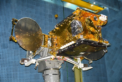
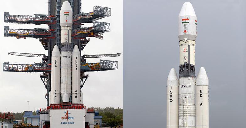
of the GSLV-D5  mission, however, is to flight-test the rocket’s all-important third stage: the indigenously-built cryogenic upper stage (CUS). The CUS, expected to be the mainstay of future GSLV flights, replaces the Russian cryogenic engine which was used in the rocket’s earlier experimental flights. There will be a lot of crossed fingers at Sriharikota during the launch, considering the new engine had a disastrous maiden flight in April 2010, shutting down less than a second after ignition, with the rocket plunging into the sea. The GSLV’s significance lies in the fact that the future of the global satellite market lies in the field of communications. The GSAT 14 satellite piggybacking the GSLV-D5 carries six Ku-band and six extended C-band transponders to help in digital audio broadcasting and other communications across the entiresubcontinent. Designed to last for a dozen years in its orbit, the satellite will replace the GSAT-3 (EDUSAT) which has been in orbit for 10 years. The big boosters in the GSLV series can hoist heavy communication satellites into geosynchronous orbits 36,000 km above the equator. In this position, the satellite keeps pace with Earth’s rotation and, as a result, appears stationary from the ground. This makes it easier to build simpler antennas on the ground, which do not have to track moving satellites in the sky. But powerful GSLV Mark IIIs (like the GSLV-D5) that can carry five-tonne satellites need cryogenic engines. These engines use fuels like oxygen and hydrogen inliquid form — stored at extremely low temperatures — to produce enormous amounts of thrust per unit mass (engineering parlance for the mass of fuel the engine requires to provide maximum thrust for a specific period such as, say, pounds of fuel per hour per pound of thrust). Rockets powered by cryogenic motors, therefore, need to carry much less fuel than would otherwise be required. Cryogenic fuels are also extremely clean as they give out only water while burning. A successful GSLV-D5 flight will make India only the sixth nation to possess this cutting edge technology, joining the United States, Russia, France, Japan and China in an elite club. India’s cryogenicmotor development encountered some rough weather in 1993 when exaggerated US jitters — that India might utilise its space capabilities for military purposes — led to Moscow chickening out of a cryo-engine technology transfer deal with New Delhi. Of course, the real reason for guarding cryogenic engine technology so zealously probably had more to do with economics than national security. India’s arrival in the global heavy-lift launch market as a low cost launch source would have threatened the business interests of Europe, Russia, and the US. In hindsight, though, it seems to have been a disguised blessing for Indian scientists who were forced to developthe technology on their own. The GSLV will reduce India’s dependence on foreign launchers like the ESA’s Ariane to launch INSAT-class satellites. Isro sources speak of plans to fly two more GSLVs at six-month-intervals before using the third one for the Chandrayaan-2 Moon mission. The GSLV-Mark III is also earmarked for launching human space flights in future and building orbiting space stations. Isro has built up an impressive portfolio of comparatively cheap space products and services that are attractive to foreign space agencies that want to outsource space missions. Together with the old workhorse Polar Satellite Launch Vehicle (PSLV), the GSLV can bolsterIndia’s launch capability, which already boasts 30 to 35% cheaper launches than other countries. That said, however, the space agency cannot afford to ignore the fact that other players jostling in the international space market are constantly pushing the bar still higher. For the moment, though, all eyes will be on the GSLV-D5 mission, which will determine how soon Isro can claim its rightful share of the $300 billion global space market. GSLV D5 successfully places GSAT-14 on orbit: Sriharikota: The Indian Space Research Organisation or ISRO achieved another milestone today as it successfully launched the Geo-synchronous Satellite Launch Vehicle or GSLV-D5 from the space port at Sriharikota in Andhra Pradesh. The advanced GSAT-14 communications satellite that GSLV-D5 is carrying has also been separated from the
rocket. If  launched into orbit successfully, the Rs. 350-crore mission will mark India's entry into the multi-billion dollar commercial launcher market on a fully indigenous large rocket. An India-made cryogenic engine powers the GSLV-D5, which stands almost 50 meters tall (as high as a 17-storey building) and weighs a whopping 415 tons (as much 80 full grown elephants). "I am happy to saythat Team ISRO has done it," ISRO chief Dr K Radhakrishnan said after what was called a make-or-break launch owing to two failures earlier. The GSLV program had suffered twin back-to-back failures three years ago and its last launch in August was aborted minutes before lift-off. On August 19, 2013, a major mishap was averted and the launch of the GSLV was aborted 74 minutes before lift-off after ISRO scientists found that about 750 kilograms of highly inflammable and explosive fuel had leaked out in the second stage. Source: Article1, Images: http://antariksh-space.blogspot.in
Read More........

Study Finds Climate Link To 'Atmospheric River' Storms

Image Credit: Anthony Wimmers and Chris Velden, University of Wisconsin-CI
A new NASA-led study of "atmospheric river" storms from the Pacific Ocean may help scientists better predict major winter snowfalls that hit West Coast mountains and lead to heavy spring runoff and sometimes flooding. Animation of the atmospheric-river event. This animation shows an atmospheric river event over Dec. 18-20, 2010. High-altitude winds pull large amounts of water vapor (yellow and orange) from the tropical ocean near Hawaii and carry it straight to California. Atmospheric rivers -- short-lived wind tunnels that carry water vapor from tropical oceans to mid-latitude land areas -- are prolific producers of rain and snow on California's Sierra Nevada mountains. The finding, published in the journal Water Resources Research, has major implications for water management in the West, where Sierra runoff is used for drinking water, agriculture and hydropower. The research team studied how two of the most common atmospheric circulation patterns in the Northern Hemisphere interact with atmospheric rivers. They found when those patterns line up in a certain way, they create a virtual freeway that leads the moisture-laden winds straight to the Sierras. Bin Guan of the Joint Institute for Regional Earth System Science and Engineering, a collaboration between NASA's Jet Propulsion Laboratory (JPL) in Pasadena, Calif., and the University of California Los Angeles (UCLA), led a team of scientists from NASA, UCLA , and the National Oceanic and Atmospheric Administration (NOAA) on this research. The high- and low-pressure anomaly areas on the map, shown in red/orange (high) and blue (low), are typical of the combined negative phases of the Arctic Oscillation and the Pacific/North American teleconnection. The low-pressure system northwest of California directs atmospheric rivers toward the Sierra Nevada, and the high-pressure systems at higher latitudes prevent the low from drifting northward away from California. 
Image credit: Bin Guan, NASA/JPL-Caltech and UCLA.
An atmospheric river is a narrow stream of wind, about a mile high and sometimes of hurricane strength. Crossing the warm tropical Pacific in a few days, it becomes laden with water vapor. A moderate-sized atmospheric river carries as much water as the Mississippi River dumps into the Gulf of Mexico in an average week. When the river comes ashore and stalls over higher terrain, the water falls as snow or rain. "Atmospheric rivers are the bridge between climate and West Coast snow," said Guan. "If scientists can predict these atmospheric patterns with reasonable lead times, we'll have a better understanding of water availability and flooding in the region." The benefit of improving flood prediction alone would be significant. A single California atmospheric-river storm in 1999 caused 15 deaths and $570 million in damage. Guan's team used data from the JPL-developed Atmospheric Infrared Sounder (AIRS) instrument on NASA’s Aqua satellite, along with NOAA satellite data and snowpack data from the California Department of Water Resources. They looked at the extremely snowy winter of 2010-2011, when 20 atmospheric rivers made landfall. The team compared the dates of these events with the phases of the Arctic Oscillation (AO) and the Pacific/North American teleconnection (PNA). These large-scale weather patterns wax and wane, stretching thousands of miles across the atmosphere and shaping the climate of the mid-latitudes, somewhat as the better-known El Niño and La Niña patterns do in the tropical Pacific. Satellite water-vapor measurements from Dec. 18, 2010, show an atmospheric river making landfall in California. Continents appear in black. The belt of very moist air (red) centered on the equator is the reservoir that supplies atmospheric rivers. On this date, the AO and PNA were both in their negative phases. Water vapor data from the Special Sensor Microwave Imager and the Special Sensor Microwave Imager/Sounder instruments on Defense Meteorological Satellite Program satellites. 
Image credit: Bin Guan, NASA/JPL-Caltech and UCLA.
Each pattern affects a different part of the Northern Hemisphere by seesawing between phases of lower-than-average and higher-than-average air pressure over various parts of the globe. For example, the negative phase of the AO is associated with higher pressure in the Arctic and lower pressure in the surrounding lower latitudes. In the positive phase, those highs and lows are reversed. The phases of each pattern change irregularly and at varying intervals. The researchers charted these phases throughout the winter of 2010-2011. During 15 of the winter's 20 atmospheric river occurrences, both patterns were in the negative phase. The team then looked at the period 1998-2011 and found a similar correspondence: more atmospheric rivers occurred when both patterns were negative. According to Guan, in the double-negative periods the high- and low-pressure systems associated with that phase in each pattern mesh to create a lingering atmospheric low-pressure system just northwest of California. That low directs the atmospheric river fire hose straight toward the Sierra Nevadas. Guan points out that the double-negative phase correlation is rare. "I looked at 50 years of atmospheric data. Only five months had those phases of the PNA and AO occurring together for more than 15 days of the month," he said. AIRS was built and is managed by JPL for NASA's Science Mission Directorate in Washington. Aqua is managed by NASA's Goddard Space Flight Center, Greenbelt, Md. JPL is a division of the California Institute of Technology in Pasadena. Contacts and sources: Alan Buis Jet Propulsion Laboratory. Source: Nano Patents And Innovations
Read More........

Shapley Supercluster

While scanning the sky for the oldest cosmic light, ESA’s Planck satellite has captured snapshots of some of the largest objects populating the Universe today: galaxy clusters and superclusters. Several hundred galaxies and the huge amounts of gas that permeate them are depicted in this view of the core of the Shapley Supercluster, the largest cosmic structure in the local Universe. The supercluster was discovered in the 1930s by American astronomer Harlow Shapley, as a remarkable concentration of galaxies in the Centaurus constellation. Boasting more than 8000 galaxies and with a total mass more than ten million billion times the mass of the Sun, it is the most massive structure within a distance of about a billion light-years from our Milky Way Galaxy. The hot gas pervading galaxy clusters shines brightly in X-rays, but it is also visible at microwave wavelengths, which Planck sees as a distinctive signature in the Cosmic Microwave Background – the afterglow of the Big Bang. Looking for this signature – called the Sunyaev–Zel’dovich effect – Planck has already spotted more than 1000 galaxy clusters, including several superclusters and pairs of interacting clusters. This composite image of the core of the Shapley Supercluster combines the gas detected with Planck at large scales between the members of the supercluster (shown in blue) with that detected in X-rays within the galaxy clusters of Shapley using the Rosat satellite (pink), as well as a view of its rich population of galaxies as observed at visible wavelengths in the Digitised Sky Survey. The largest pink blobs of X-rays identify the two galaxy clusters Abell 3558 on the right and Abell 3562 on the left, as well as a couple of smaller groups between them. The image measures 3.2 x 1.8 square degrees and shows the central portion of the Shapley Supercluster. It was produced by reconstructing the Sunyaev–Zel’dovich effect from the Planck frequency maps, and was first published in a Planck Collaboration paper in March 2013. Image credit: ESA & Planck Collaboration / Rosat/ Digitised Sky SurveySource: Article
Read More........

NASA-Funded Scientists Detect Water on Moon's Surface that Hints at Water Below


Chandrayaan-1 Moon mission description
NASA-funded lunar research has yielded evidence of water locked in mineral grains on the surface of the 
moon from an unknown source deep beneath the surface. Using data from NASA's Moon Mineralogy Mapper (M3) instrument aboard the Indian Space Research Organization's Chandrayaan-1 spacecraft, scientists remotely detected magmatic water, or water that originates from deep within the moon's interior, on the surface of the moon. The findings, published Aug. 25 in Nature Geoscience, represent the first detection of this form of water from lunar orbit. Earlier studies had shown the existence of magmatic water in lunar samples returned during the Apollo program. M3 imaged the lunar impact crater Bullialdus, which lies near the lunar equator. Scientists were interested in studying this area because they could better quantify the amount of water inside the rocks due to the crater's location and the type of rocks it held. The central peak of the crater is made up of a type of rock that forms deep within the lunar crust and mantle when magma is trapped underground. "This rock, which normally resides deep beneath the surface, was excavated from the lunar depths by the impact that formed Bullialdus crater," said Rachel Klima, a planetary geologist at the Johns Hopkins University
NASA patch / NASA / ISRO - Chandrayaan-1 Moon Mineralogy Mapper (M3) patch's.
Applied Physics Laboratory (APL) in Laurel, Md. "Compared to its surroundings, we found that the central portion of this crater contains a significant amount of hydroxyl - a molecule consisting of one oxygen atom and one hydrogen atom -- which is evidence that the rocks in this crater contain water that originated beneath the lunar surface," Klima said. In 2009, M3 provided the first mineralogical map of the lunar surface and discovered water molecules in the polar regions of the moon. This water is thought to be a thin layer formed from solar wind hitting the moon's surface. Bullialdus crater is in a region with an unfavorable environment for solar wind to produce significant amounts of water on the surface. "NASA missions like Lunar Prospector and the Lunar Crater Observation and Sensing Satellite and instruments like M3 have gathered crucial data that fundamentally changed our understanding of whether water exists on the surface of the moon," said S. Pete Worden, center director at NASA's Ames Research Center in Moffett Field, Calif. "Similarly, we hope that
LADEE Mission poster
upcoming NASA missions such as the Lunar Atmosphere and Dust Environment Explorer, or LADEE, will change our understanding of the lunar sky." The detection of internal water from orbit means scientists can begin to test some of the findings from sample studies in a broader context, including in regions that are far from where the Apollo sites are clustered on the near side of the moon. For many years, researchers believed that the rocks from the moon were bone-dry and any water detected in the Apollo samples had to be contamination from Earth. "Now that we have detected water that is likely from the interior of the moon, we can start to compare this water with other characteristics of the lunar surface," said Klima. "This internal magmatic water also provides clues about the moon's volcanic processes and internal composition, which helps us address questions about how the moon formed, and how magmatic processes changed as it cooled." APL is a not-for-profit division of Johns Hopkins University. Joshua Cahill and David Lawrence of APL and Justin Hagerty of the U.S. Geological Survey's Astrogeology Science Center in Flagstaff, Ariz., co-authored the paper. NASA's Lunar Advanced Science and Engineering Program, the NASA Lunar Science Institute (NLSI) at Ames and the NASA Planetary Mission Data Analysis Program supported the research. NLSI is a virtual organization jointly funded by NASA's Science Mission Directorate and NASA's Human Exploration and Operations Mission Directorate in Washington, to enable collaborative, interdisciplinary research in support of NASA lunar science programs. For more information about NASA programs, visit: http://www.nasa.gov. Images, Text, Credit: NASA / JPL / ISRO. Greetings, Orbiter.ch. Source: Orbiter.ch Space News
Read More........

NASA, ISRO in talks to jointly develop a satellite for the first time

US space agency NASA and India's premier space agency ISRO are in talks for jointly building a satellite for the first time. "Now, there is a feasibility study going on whether we can jointly make a satellite, with synthetic aperture radar (SAR) payloads working on two frequency bands - L-band and S-band", Chairman of Indian Space Research Organisation (ISRO) K Radhakrishnan told PTI in Bangalore. Charles F Bolden Jr, Administrator of National Aeronautics and Space Administration (NASA) of United States, visited the Space Applications Centre (SAC) of ISRO in Ahmedabad on June 25.He had a meeting with Mr Radhakrishnan, also Secretary, Department of Space, along with senior officials of ISRO to discuss the ongoing cooperative activities between ISRO and NASA and also the potential areas of future cooperation. "...the joint satellite mission is an important step. It's not making an instrument and plugging it actually. It's working together. That's what we are discussing. It (working together) should happen in the next few months", Radhakrishnan said. "Both organisations are coming together and saying let's develop it together...use your strength, use my strength. That's a good way of working", he said. "It (the proposed satellite) is interesting from scientific point of view, it's interesting from normal resource management point of view," he said. Mr Radhakrishnan said NASA's Jet Propulsion Laboratory would make the radar system "if it (in case of NASA, ISRO deciding to work together on the mission) is getting through". On ISRO's role, he said, "We will be working together. Some will be built by us, some will be built by them. So, this (work-sharing) has to be finalised", adding, data generated by the mission would be used by both ISRO and NASA. Source: Article
Read More........

CryoSat maps largest-ever flood beneath Antarctica

Site of crater
ESA’s CryoSat satellite has found a vast crater in Antarctica’s icy surface. Scientists believe the crater was left behind when a lake lying under about 3 km of ice suddenly drained. Far below the thick ice sheet that covers Antarctica, there are lakes of fresh water without a direct connection to the ocean. These lakes are of great interest to scientists who are trying to understand water transport and ice dynamics beneath the frozen Antarctic surface – but this information is not easy to obtain. One method is to drill holes through kilometres of ice to the water – a difficult endeavour in the harsh conditions of the polar regions. But instead of looking down towards the ice, a team of European scientists is looking to the sky to improve our understanding of subglacial water and its transport. By combining new measurements acquired by CryoSat with older data from NASA’s ICESat satellite, the team has mapped the large crater left behind by a lake, and even determined the scale of the flood that formed it. From 2007 to 2008, six cubic kilometres of water – about the same amount that is stored in Scotland’s Loch Ness – drained from
3D view
the lake, making it the largest event  of its kind ever recorded. That amount of water equals a tenth of the melting that occurs beneath Antarctica each year. Since the end of 2008, the lake appears to be refilling but six times slower than it drained. It could take decades to reform. The study, published recently in Geophysical Research Letters, highlights CryoSat’s unique capacity to map changes in Antarctica’s subglacial lakes in 3D, and sheds new light on events at the base of the ice sheet. CryoSat carries a radar altimeter that can ‘see’ through clouds and in the dark, providing continuous measurements over areas like Antarctica that are prone to bad weather and long periods of darkness. The radar can measure
ESA's ice mission CryoSat
both the area and depth of ice craters in high resolution, allowing scientists to calculate its volume accurately. “Thanks to CryoSat, we can now see fine details that were not apparent in older satellite data records,” said Dr Malcolm McMillan from the UK’s University of Leeds and lead author of the study ‘Three-dimensional mapping by CryoSat-2 of subglacial lake volume changes’. With every subglacial lake, there is hope of finding prehistoric marine life. The rapid draining and apparent refilling of this lake, however, suggests this was not the first time water has drained from the lake. “It seems likely that the flood water – and any microbes or sediments it contained – has been flushed into the Southern Ocean, making it difficult to imagine that life in this particular lake has evolved in isolation,” said Prof. Andrew Shepherd, a co-author of the study. About 400 lakes have been discovered at the base of the Antarctic ice sheet. When they drain, they disrupt subglacial habitats and can cause the ice above to slide more quickly into the sea. Source: Orbiter.ch Space News
Read More........

Elusive Space Wind Detected By Cluster Spacecraft

Credit: EGU
A new study provides the first conclusive proof of the existence of a space wind first proposed theoretically over 20 years ago. By analysing data from the European Space Agency’s Cluster spacecraft, researcher Iannis Dandouras detected this plasmaspheric wind, so-called because it contributes to the loss of material from the plasmasphere, a donut-shaped region extending above the Earth’s atmosphere. The results are published today in Annales Geophysicae, a journal of the European Geosciences Union (EGU).  “After long scrutiny of the data, there it was, a slow but steady wind, releasing about 1 kg of plasma every second into the outer magnetosphere: this corresponds to almost 90 tonnes every day. It was definitely one of the nicest surprises I’ve ever had!” said Dandouras of the Research Institute in Astrophysics and Planetology in Toulouse, France. The plasmasphere is a region filled with charged particles that takes up the inner part of the Earth’s magnetosphere, which is dominated by the planet’s magnetic field. To detect the wind, Dandouras analysed the properties of these charged particles, using information collected in the plasmasphere by ESA’s Cluster spacecraft. Further, he developed a filtering technique to eliminate noise sources and to look for plasma motion along the radial direction, either directed at the Earth or outer space. As detailed in the new Annales Geophysicae study, the data showed a steady and persistent wind carrying about a kilo of the plasmasphere’s material outwards each second at a speed of over 5,000 km/h. This plasma motion was present at all times, even when the Earth’s magnetic field was not being disturbed by energetic particles coming from the Sun. Researchers predicted a space wind with these properties over 20 years ago: it is the result of an imbalance between the various forces that govern plasma motion. But direct detection eluded observation until now. “The plasmaspheric wind is a weak phenomenon, requiring for its detection sensitive instrumentation and detailed measurements of the particles in the plasmasphere and the way they move,” explains Dandouras, who is also the vice-president of the EGU Planetary and Solar System Sciences Division. The wind contributes to the loss of material from the Earth’s top atmospheric layer and, at the same time, is a source of plasma for the outer magnetosphere above it. Dandouras explains: “The plasmaspheric wind is an important element in the mass budget of the plasmasphere, and has implications on how long it takes to refill this region after it is eroded following a disturbance of the planet’s magnetic field. Due to the plasmaspheric wind, supplying plasma – from the upper atmosphere below it – to refill the plasmasphere is like pouring matter into a leaky container.” The plasmasphere, the most important plasma reservoir inside the magnetosphere, plays a crucial role in governing the dynamics of the Earth’s radiation belts. These present a radiation hazard to satellites and to astronauts travelling through them. The plasmasphere’s material is also responsible for introducing a delay in the propagation of GPS signals passing through it. “Understanding the various source and loss mechanisms of plasmaspheric material, and their dependence on the geomagnetic activity conditions, is thus essential for understanding the dynamics of the magnetosphere, and also for understanding the underlying physical mechanisms of some space weather phenomena,” says Dandouras. Michael Pinnock, Editor-in-Chief of Annales Geophysicae recognises the importance of the new result. “It is a very nice proof of the existence of the plasmaspheric wind. It’s a significant step forward in validating the theory. Models of the plasmasphere, whether for research purposes or space weather applications (e.g. GPS signal propagation) should now take this phenomenon into account,” he wrote in an email. Similar winds could exist around other planets, providing a way for them to lose atmospheric material into space. Atmospheric escape plays a role in shaping a planet’s atmosphere and, hence, its habitability. More information: This research is presented in the paper ‘Detection of a plasmaspheric wind in the Earth’s magnetosphere by the Cluster spacecraft’ to appear in the EGU open access journal Annales Geophysicae on 2 July 2013. Please mention the publication if reporting on this story and, if reporting online, include a link to the paperor to the journal website. The scientific article is available online, free of charge at: http://www.ann-geophys.net/31/1143/2013/angeo-31-1143-2013.html The paper is authored by Iannis Dandouras of the Research Institute in Astrophysics and Planetology (IRAP), a joint institute of the French National Centre for Scientific Research (CNRS) and the Paul Sabatier University in Toulouse, France. The data was acquired by the CIS, Cluster Ion Spectrometry, experiment onboard ESA’s Cluster, a constellation of four spacecraft flying in formation around Earth. The European Geosciences Union (EGU) is Europe’s premier geosciences union, dedicated to the pursuit of excellence in the Earth, planetary and space sciences for the benefit of humanity, worldwide. It is a non-profit interdisciplinary learned association of scientists founded in 2002. Contacts and sources: Bárbara FerreiraEuropean Geosciences UnionSource: Nano-Patents And Innovations
Read More........

Launch of Indian PSLV C22 Rocket with IRNSS-1 satellite

Launch of Indian PSLV C22 Rocket with IRNSS-1 An Indian Polar Satellite Launch Vehicle (PSLV) succesfully launched from India today, July 1st 2013 at 18:11 UTC carrying the first of seven IRNSS satellites into orbit. Indian Regional Navigation Satellite System (IRNSS) will provide real time navigation and time data to multiple users. Indian Regional Navigation Satellite  System (IRNSS) description. 
Image credit: thehindu.com This was the very first night launch of the Indian Polar Satellite Launch Vehicle which uses four stages. India has successfully put the country’s first Navigation Satellite into orbit on Monday. A Polar Satellite Launch Vehicle blasted off from the Satish Dhawan Space Center on India’s East coast at 18:11 UTC and made a flawless ascent mission delivering the IRNSS-1A spacecraft 
to its intended orbit about 20 minutes after launch. The flight was declared a complete success – marking the birth of India’s own navigation constellation, the Indian Regional Navigation System that will cover the 
Image above: LIFTOFF of an Indian PSLV from Satish Dhawan carrying India’s first navigation satellite. India’s first navigation satellite has arrived in orbit. Photo Screen Capture from ISRO TV. 
Indian Regional Navigation Satellite System (IRNSS). Credit: ISRO 
country and surrounding areas. Credit ISRO. For more information about Indian Space Research Organization (ISRO), visit: http://www.isro.org/ Images (mentioned), Video, Text, Credits: ISRO / ISRO TV. Best regards, Source: Orbiter.ch Space News
Read More........