Curious Kids: what was the biggest dinosaur that ever lived?

What actually was the biggest dinosaur?

– Zavier, 14, Tauranga, New Zealand.

Great question Zavier, and one that palaeontologists (scientists who study fossil animals and plants) are interested in all around the world.

And let’s face it, kids of all ages (and I include adults here) are fascinated by dinosaurs that break records for the biggest, the longest, the scariest or the fastest. It’s why, to this day, one of most famous dinosaurs is still Tyranosaurus rex, the tyrant king.

These record-breaking dinosaurs are part of the reason why the Jurassic Park movie franchise has been so successful. Just think of the scene where Dr Alan Grant (played by New Zealand actor Sam Neill) is stunned by the giant sauropod dinosaur rearing up to reach the highest leaves in the tree with its long neck.

But how do scientists work out how big and heavy a dinosaur was? And what were the biggest dinosaurs that ever lived?

Calculating dinosaur size

In an ideal world, calculating how big a dinosaur was would be easy – with a nearly complete skeleton. Standing next to the remarkable Triceratops skeleton on permanent display at Melbourne Museum makes you realise how gigantic and formidable these creatures were.

By measuring bone proportions (such as length, width or circumference) and plugging them into mathematical formulas and computer models, scientists can compare the measurements to those of living animals. They can then work out the likely size and weight of dinosaurs.

Calculating the size of dinosaurs is easy when you have near complete skeletons like this Triceratops at Melbourne Museum. Ginkgoales via Wikimedia Commons, CC BY-NC-SA

Every palaeontologist has their own favourite formula or computer model. Some are more accurate than others, which can lead to heated arguments!

In palaeontology, however, we are not always blessed with nearly complete skeletons. In a process called “taphonomy” – basically, what happens to the bones after an animal dies – dinosaur skeletons can be broken up and bones lost.

The more fragmented the remains of a dinosaur are, the more error is introduced into size and weight estimates.

Enter the titanosaurs

If we could travel back in time to South America during the Cretaceous period (about 143 million to 66 million years ago), we’d find a land ruled by a group of four-legged, long-necked and long-tailed, plant-eating sauropods. They would have towered over us, and the ground would shake with every step they took.

These were the titanosaurs. They reached their largest sizes during this period, before an asteroid crashed into what is now modern day Mexico 66 million years ago, making them extinct.

There are several contenders among the titanosaurs for the biggest dinosaur ever. Even the list below is controversial, with my palaeontology students pointing out several other possible contenders.

But based on six partial skeletons, the best estimate is for Patagotitan, which is thought to have been 31 meters long and to have weighed 50–57 tonnes.

A couple of others might have been as big or even bigger. Argentinosaurus has been calculated to be longer and heavier at 30–35 metres and 65–80 tonnes. And Puertasaurus was thought to be around 30 metres long and 50 tonnes.

But while the available bones of Argentinosaurus and Puertasaursus suggest reptiles of colossal size (the complete thigh bone of Argentinosaurus is 2.5 metres long!), there is currently not enough fossil material to be confident of those estimates.

Spinosaurus rules North Africa

An ocean away from South America’s titanosaurs, Spinosaurus lived in what is now North Africa during the Cretaceous period.

By a very small margin, Spinosaurus is currently thought to have been the largest carnivorous (meat-eating) dinosaur, weighing in at 7.4 tonnes and 14 meters long. Other Cretaceous giants are right up there, too, including Tyranosaurus rex from North America, Gigantosaurus from South America, and Carcharodontosaurus from North Africa.

Spinosaurus is unique among predatory dinosaurs in that it was semi-aquatic and had adapted to eating fish. You can see in the picture above how similar its skull shape was to a modern crocodile.

Palaeontology is now more popular than ever – maybe because of the ongoing Jurassic Park series – with a fossil “gold rush” occurring in the Southern Hemisphere.

The latest Jurassic Park movie – in cinemas from July 2025 – is about finding the biggest prehistoric species from land, sea, and air.

Members of the public (known as “fossil forecasters”) are making new discoveries all the time.

So, who knows? The next discovery might turn out to be a new record holder as the biggest or longest dinosaur to have ever lived. There can be only one!


Hello curious kids! Do you have a question you’d like an expert to answer? Ask an adult to send your question to curiouskids@theconversation.edu.auThe Conversation

Nic Rawlence, Associate Professor in Ancient DNA, University of Otago

This article is republished from The Conversation under a Creative Commons license. Read the original article.

Read More........

What’s the difference between climate and weather models? It all comes down to chaos

Weather forecasts help you decide whether to go for a picnic, hang out your washing or ride your bike to work. They also provide warnings for extreme events, and predictions to optimise our power grid.

To achieve this, services such as the Australian Bureau of Meteorology use complex mathematical representations of Earth and its atmosphere – weather and climate models.

The same software is also used by scientists to predict our future climate in the coming decades or even centuries. These predictions allow us to plan for, or avoid, the impacts of future climate change.

Weather and climate models are highly complex. The Australian Community Climate and Earth System Simulator, for example, is comprised of millions of lines of computer code.

Without climate and weather models we would be flying blind, both for short-term weather events and for our long-term future. But how do they work – and how are they different?

The same physical principles

Weather is the short-term behaviour of the atmosphere – the temperature on a given day, the wind, whether it’s raining and how much. Climate is about long-term statistics of weather events – the typical temperature in summer, or how often thunderstorms or floods happen each decade.

The reason we can use the same modelling tools for both weather and climate is because they are both based on the same physical principles.

These models compile a range of factors – the Sun’s radiation, air and water flow, land surface, clouds – into mathematical equations. These equations are solved on a bunch of tiny three-dimensional grid boxes and pieced together to predict the future state.

These boxes are sort of like pixels that come together to make the big picture.

These solutions are calculated on a computer – where using more grid boxes (finer resolution) gives better answers, but takes more computing resources. This is why the best predictions need a supercomputer, such as the National Computational Infrastructure’s Gadi, located in Canberra.

Because weather and climate are governed by the same physical processes, we can use the same software to predict the behaviour of both.

But there most of the similarities end.

The starting point

The main differences between weather and climate come down to a single concept: “initialisation”, or the starting point of a model.

In many cases, the simplest prediction for tomorrow’s weather is the “persistence” forecast: tomorrow’s weather will be similar to today. It means that, irrespective of how good your model is, if you start from the wrong conditions for today, you have no hope of predicting tomorrow.

Persistence forecasts are often quite good for temperature, but they’re less effective for other aspects of weather such as rainfall or wind. Since these are often the most important aspects of weather to predict, meteorologists need more sophisticated methods.

So, weather models use complex mathematics to create models that include weather information (from yesterday and today) and then make a good prediction of tomorrow. These predictions are a big improvement on persistence forecasts, but they won’t be perfect.

In addition, the further ahead you try to predict, the more information you forget about the initial state and the worse your forecast performs. So you need to regularly update and rerun (or, to use modelling parlance, “initialise”) the model to get the best prediction.

Weather services today can reliably predict three to seven days ahead, depending on the region, the season and the type of weather systems involved.

Chaos reigns

If we can only accurately predict weather systems about a week ahead before chaos takes over, climate models have no hope of predicting a specific storm next century.

Instead, climate models use a completely different philosophy. They aim to produce the right type and frequency of weather events, but not a specific forecast of the actual weather.

The cumulative effect of these weather events produces the climate state. This includes factors such as the average temperature and the likelihood of extreme weather events.

So, a climate model doesn’t give us an answer based on weather information from yesterday or today – it is run for centuries to produce its own equilibrium for a simulated Earth.

Because it is run for so long, a climate (also known as Earth system) model will need to account for additional, longer-term processes not factored into weather models, such as ocean circulation, the cryosphere (the frozen portions of the planet), the natural carbon cycle and carbon emissions from human activities.

The additional complexity of these extra processes, combined with the need for century-long simulations, means these models use a lot of computing power. Constraints on computing means that we often include fewer grid boxes (that is, lower resolution) in climate models than weather models.

A machine learning revolution?

Is there a faster way?

Enormous strides have been made in the past couple of years to predict the weather with machine learning. In fact, machine learning-based models can now outperform physics-based models.

But these models need to be trained. And right now, we have insufficient weather observations to train them. This means their training still needs to be supplemented by the output of traditional models.

And despite some encouraging recent attempts, it’s not clear that machine learning models will be able to simulate future climate change. The reason again comes down to training – in particular, global warming will shift the climate system to a different state for which we have no observational data whatsoever to train or verify a predictive machine learning model.

Now more than ever, climate and weather models are crucial digital infrastructure. They are powerful tools for decision makers, as well as research scientists. They provide essential support for agriculture, resource management and disaster response, so understanding how they work is vital.The Conversation

Andy Hogg, Professor and Director of ACCESS-NRI, Australian National University; Aidan Heerdegen, Leader, ACCESS-NRI Model Release Team, Australian National University, and Kelsey Druken, Associate Director (Release Management), ACCESS-NRI, Australian National University

This article is republished from The Conversation under a Creative Commons license. Read the original article.

Read More........

Scientists Drill Ice Core–2 Miles Down–Extracting 1.2 Million Years of Climate Record On Earth

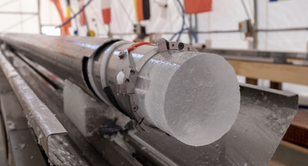
Antarctica ice core – PNRA / IPEV via SWNS

An international team of scientists in the Antarctic has successfully extracted what is believed to be the world’s oldest ice—a historic milestone for climate science.

They drilled down almost two miles to extract 2.8-km of ice core, reaching the actual bedrock beneath the Antarctic ice sheet.

The air bubbles trapped inside the ice are “like tiny time capsules of Earth’s atmospheric past”. The samples equate to a continuous record of climate history dating back to 1.2 million years ago, which could illuminate the mysteries of glacial climate cycles.

This was the fourth Antarctic field mission for the Europeans behind the ‘Beyond EPICA – Oldest Ice’ project, funded by the European Commission.

They achieved more than 200 days of successful drilling and ice core processing operations across four seasons in the harsh environment of the central Antarctic plateau, working at an altitude of 3,200 meters above sea level with an average summer temperature of -35°C.

The ice core from Beyond EPICA will offer unprecedented insights into the Mid-Pleistocene Transition, a remarkable period between 900,000 and 1.2 million years ago when glacial cycles slowed down from 41,000-years to 100,000-year intervals.

The reasons behind this shift remain one of climate science’s enduring mysteries, one which this project seeks to unravel.
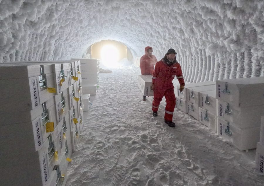
Collecting and classifying ice core samples in Antarctic – PNRA / IPEV via SWNS

“We have marked a historic moment for climate and environmental science,” said Carlo Barbante, Coordinator of Beyond EPICA and professor at Ca’ Foscari University of Venice, a member of the Institute of Polar Sciences of the National Research Council of Italy (Cnr-Isp).

“This is the longest continuous record of our past climate from an ice core, and it can reveal the interlink between the carbon cycle and temperature of our planet.”The team speculated that even older ice—dating back 2.58 million years ago—may be discovered within the core’s base. Scientists Drill Ice Core–2 Miles Down–Extracting 1.2 Million Years of Climate Record On Earth

Read More........

Some of Earth’s most ancient lifeforms can live on hydrogen – and we can learn from their chemical powers

Three-quarters of all matter in the universe is made up of hydrogen. The young Earth was also rich in hydrogen, thanks to fierce geological and volcanic activity.

Just as stars burn hydrogen to produce heat and light through nuclear reactions, life emerged by extracting energy from this simple molecule via chemical reactions.

Some of these early life forms were archaea: an enigmatic third form of life only discovered in the 1970s. (The other two forms are bacteria and eukaryotes, the group that includes all animals, plants and fungi.)

We have studied thousands of species of archaea to understand how they have thrived for billions of years on our constantly changing planet. In their genetic blueprints we found instructions for producing special enzymes (called hydrogenases) to harvest energy from hydrogen gas, which lets them survive in some of the most punishing environments on Earth. Our latest research is published in Cell and Nature Communications.

A life powered by hydrogen

Archaea are found in places where no other life can survive. For example, some flourish in boiling hot springs where the water is so acidic it would dissolve iron.

Here, hydrogen is continually formed from the geothermal processes in Earth’s crust. Archaea devour this hydrogen to repair their bodies and even sometimes grow in otherwise deadly conditions.

We found some archaea can even make use of the minute amounts of hydrogen present in the air as an additional food source. This ability would likely help them survive transport through the atmosphere from one hydrogen-rich hot spring to another.

The authors investigating hydrogenases in archaea. Julia Veitch

Surviving in the dark

Many archaea are not found on the surface, but live a humble life far underground. Plants and animals can’t survive in this environment because there is no light or oxygen to sustain them.

Archaea have found a solution: they break down deeply buried organic matter from plant or animal remains. They do so through a process called “hydrogen-forming fermentation”.

Just as in the process of beer fermentation yeasts convert sugar to produce carbon dioxide, these dark-dwelling archaea convert organic matter to produce hydrogen gas.

This process releases some energy, but only a little. To survive, some archaea form ultra-small cells to minimize their energy needs. Many are also parasites of other microbes, stealing organic matter to fuel their own growth.

Archaea making methane

Many archaea live in extreme environments, but some find a warm home in animals.

In the animal intestine, many bacteria help digest food through hydrogen-forming fermentation. But a group of archaea known as methanogens eat hydrogen and breathe out the potent greenhouse gas: methane.

Methanogens are especially abundant and active in the guts of cattle, which are responsible for around one-third of human-caused methane emissions. We have also been working on ways to inhibit the activity of gut methanogens to reduce these emissions.

These same archaea are also responsible for methane emissions from lots of other sources, from termite mounds to thawing permafrost and even trees.

Learning from archaea’s hydrogen economy

As our societies try to move away from fossil fuels, we may be able to learn from the hydrogen economy of archaea, which has thrived for billions of years.

Much of Earth’s hydrogen is tied up in water. (It’s the H in H₂O.) To extract the hydrogen and work with it, industries currently need expensive catalysts such as platinum. However, there are also biological hydrogen catalysts, enzymes called hydrogenases, that don’t require precious metals and work under a wider range of conditions.

We have found that some archaea make highly streamlined hydrogenases. These enzymes can form a basis for more efficient and economical hydrogen catalysts.

A diagram showing a streamlined hydrogenase enzyme from archaea. Rhys Grinter

Hydrogen and the history of life

Perhaps hydrogen is a key to our future energy. But it’s worth mentioning that hydrogen also helps explains our past.

The first eukaryotes (the ancestors of all animals, plants and fungi) evolved some two billion years ago, when an archaeal cell and a bacterial cell merged together.

Why did they merge? The most widely accepted theory, known as “the hydrogen hypothesis”, suggests the merger of two cells allow them to more efficiently exchange hydrogen gas. A likely scenario is the archaeal cell survived by making hydrogen, which the bacterial cell then ate to make its own energy.

Eventually, this process gave rise to all eukaryotes over a billion years of evolution. Most modern eukaryotes, including humans, have since lost the ability to use hydrogen.

But traces of the ancient archaea and bacteria still exist. The body of our cells come from archaea, while the energy-producing organelles inside the cells called mitochondria are derived from bacteria.

Hydrogen may be simple, but it has helped create much of the complexity on Earth.The Conversation

Pok Man Leung, Research Fellow in Microbiology, Monash University and Chris Greening, Professor, Microbiology, Monash University

This article is republished from The Conversation under a Creative Commons license. Read the original article.

Read More........

Studies show climate change caused Earth's axis to meander 10 metres in last 120 years


New Delhi, (IANS) Two NASA-funded studies have shown that melting ice, dwindling groundwater, and rising seas, a result of climate change, has also led to the Earth's axis to meander 10 metres in the last 120 years.

In the first study, published in Nature Geoscience, researchers analysed polar motion across 12 decades.

The scientists from ETH Zurich in Switzerland attributed 90 per cent of recurring fluctuations in polar motions between 1900 and 2018 to changes in groundwater, ice sheets, glaciers, and sea levels.

The remainder mostly resulted from Earth's interior dynamics, like the wobble from the tilt of the inner core concerning the bulk of the planet, they said.

Changes caused due to Earth's rising temperatures "are strong drivers of the changes we’re seeing in the planet’s rotation," said Surendra Adhikari, a co-author of both papers and a geophysicist at NASA’s Jet Propulsion Laboratory in Southern California.

The second study, published in Proceedings of the National Academy of Sciences, showed that since 2000, days have been lengthening by 1.33 milliseconds.

This change is attributed to the accelerated melting of glaciers and ice sheets due to human-caused greenhouse emissions.

The lengthening of days could decelerate by 2100 if emissions are significantly reduced.However, if emissions continue to rise, the effect could reach 2.62 milliseconds per century, surpassing the influence of the Moon's tidal pull, which has been increasing Earth's day length by 2.4 milliseconds per century, the scientists said. Studies show climate change caused Earth's axis to meander 10 metres in last 120 years | MorungExpress | morungexpress.com
Read More........

Some of Earth’s most ancient lifeforms can live on hydrogen – and we can learn from their chemical powers

Three-quarters of all matter in the universe is made up of hydrogen. The young Earth was also rich in hydrogen, thanks to fierce geological and volcanic activity.

Just as stars burn hydrogen to produce heat and light through nuclear reactions, life emerged by extracting energy from this simple molecule via chemical reactions.

Some of these early life forms were archaea: an enigmatic third form of life only discovered in the 1970s. (The other two forms are bacteria and eukaryotes, the group that includes all animals, plants and fungi.)

We have studied thousands of species of archaea to understand how they have thrived for billions of years on our constantly changing planet. In their genetic blueprints we found instructions for producing special enzymes (called hydrogenases) to harvest energy from hydrogen gas, which lets them survive in some of the most punishing environments on Earth. Our latest research is published in Cell and Nature Communications.

A life powered by hydrogen

Archaea are found in places where no other life can survive. For example, some flourish in boiling hot springs where the water is so acidic it would dissolve iron.

Here, hydrogen is continually formed from the geothermal processes in Earth’s crust. Archaea devour this hydrogen to repair their bodies and even sometimes grow in otherwise deadly conditions.

We found some archaea can even make use of the minute amounts of hydrogen present in the air as an additional food source. This ability would likely help them survive transport through the atmosphere from one hydrogen-rich hot spring to another.

The authors investigating hydrogenases in archaea. Julia Veitch

Surviving in the dark

Many archaea are not found on the surface, but live a humble life far underground. Plants and animals can’t survive in this environment because there is no light or oxygen to sustain them.

Archaea have found a solution: they break down deeply buried organic matter from plant or animal remains. They do so through a process called “hydrogen-forming fermentation”.

Just as in the process of beer fermentation yeasts convert sugar to produce carbon dioxide, these dark-dwelling archaea convert organic matter to produce hydrogen gas.

This process releases some energy, but only a little. To survive, some archaea form ultra-small cells to minimize their energy needs. Many are also parasites of other microbes, stealing organic matter to fuel their own growth.

Archaea making methane

Many archaea live in extreme environments, but some find a warm home in animals.

In the animal intestine, many bacteria help digest food through hydrogen-forming fermentation. But a group of archaea known as methanogens eat hydrogen and breathe out the potent greenhouse gas: methane.

Methanogens are especially abundant and active in the guts of cattle, which are responsible for around one-third of human-caused methane emissions. We have also been working on ways to inhibit the activity of gut methanogens to reduce these emissions.

These same archaea are also responsible for methane emissions from lots of other sources, from termite mounds to thawing permafrost and even trees.

Learning from archaea’s hydrogen economy

As our societies try to move away from fossil fuels, we may be able to learn from the hydrogen economy of archaea, which has thrived for billions of years.

Much of Earth’s hydrogen is tied up in water. (It’s the H in H₂O.) To extract the hydrogen and work with it, industries currently need expensive catalysts such as platinum. However, there are also biological hydrogen catalysts, enzymes called hydrogenases, that don’t require precious metals and work under a wider range of conditions.

We have found that some archaea make highly streamlined hydrogenases. These enzymes can form a basis for more efficient and economical hydrogen catalysts.

A diagram showing a streamlined hydrogenase enzyme from archaea. Rhys Grinter

Hydrogen and the history of life

Perhaps hydrogen is a key to our future energy. But it’s worth mentioning that hydrogen also helps explains our past.

The first eukaryotes (the ancestors of all animals, plants and fungi) evolved some two billion years ago, when an archaeal cell and a bacterial cell merged together.

Why did they merge? The most widely accepted theory, known as “the hydrogen hypothesis”, suggests the merger of two cells allow them to more efficiently exchange hydrogen gas. A likely scenario is the archaeal cell survived by making hydrogen, which the bacterial cell then ate to make its own energy.

Eventually, this process gave rise to all eukaryotes over a billion years of evolution. Most modern eukaryotes, including humans, have since lost the ability to use hydrogen.

But traces of the ancient archaea and bacteria still exist. The body of our cells come from archaea, while the energy-producing organelles inside the cells called mitochondria are derived from bacteria.

Hydrogen may be simple, but it has helped create much of the complexity on Earth.The Conversation

Pok Man Leung, Research Fellow in Microbiology, Monash University and Chris Greening, Professor, Microbiology, Monash University

This article is republished from The Conversation under a Creative Commons license. Read the original article.

Read More........

First 'extreme' solar storm in 20 years brings spectacular auroras


The most powerful solar storm in more than two decades struck Earth on Friday, triggering spectacular celestial light shows from Tasmania to Britain -- and threatening possible disruptions to satellites and power grids as it persists into the weekend.

The first of several coronal mass ejections (CMEs) -- expulsions of plasma and magnetic fields from the Sun -- came just after 1600 GMT, according to the National Oceanic and Atmospheric Administration (NOAA)'s Space Weather Prediction Center.

It was later upgraded to an "extreme" geomagnetic storm -- the first since the "Halloween Storms" of October 2003 caused blackouts in Sweden and damaged power infrastructure in South Africa. More CMEs are expected to pummel the planet in the coming days.

Social media lit up with people posting pictures of auroras from northern Europe and Australasia.

"We've just woken the kids to go watch the Northern Lights in the back garden! Clearly visible with the naked eye," Iain Mansfield in Hertford, England, told AFP.

That sense of wonder was shared in Australia's island state of Tasmania.

"Absolutely biblical skies in Tasmania at 4am this morning. I'm leaving today and knew I could not pass up this opportunity," photographer Sean O' Riordan posted on social media platform X alongside a photo.


The excitement spread across Europe and North America, from Mont Saint-Michel on the French coast to Payette, Idaho, where the sky shimmered with green light above the western US states.

Authorities notified satellite operators, airlines and the power grid to take precautionary steps for potential disruptions caused by changes to Earth's magnetic field.

Elon Musk, whose Starlink satellite internet operator has some 5,000 satellites in low Earth orbit, described the solar storm as the "biggest in a long time."

"Starlink satellites are under a lot of pressure, but holding up so far," Musk posted on his X platform.

Unlike solar flares, which travel at the speed of light and reach Earth in around eight minutes, CMEs travel at a more sedate pace, with officials putting the current average at 800 kilometers per second.

The CMEs emanated from a massive sunspot cluster that is 17 times wider than our planet. The Sun is approaching the peak of an 11-year cycle that brings heightened activity.

- 'Go outside tonight and look' -

Mathew Owens, a professor of space physics at the University of Reading, told AFP that how far the effects would be felt over the planet's northern and southern latitudes would depend on the storm's final strength.


"Go outside tonight and look would be my advice because if you see the aurora, it's quite a spectacular thing," he said. People with eclipse glasses can also look for the sunspot cluster during the day.

NOAA's Brent Gordon encouraged the public to try to capture the night sky with phone cameras even if they couldn't see auroras with their naked eyes.

"Just go out your back door and take a picture with the newer cell phones and you'd be amazed at what you see in that picture versus what you see with your eyes."

- Spacecraft and pigeons -

Fluctuating magnetic fields associated with geomagnetic storms induce currents in long wires, including power lines, which can potentially lead to blackouts. Long pipelines can also become electrified, leading to engineering problems.


Spacecraft are also at risk from high doses of radiation, although the atmosphere prevents this from reaching Earth.

NASA has a dedicated team looking into astronaut safety and can ask astronauts on the International Space Station to move to places within the outpost that are better shielded.

Following one particularly strong flare peak, the US Space Weather Prediction Center said users of high-frequency radio signals "may experience temporary degradation or complete loss of signal on much of the sunlit side of Earth."

Even pigeons and other species that have internal biological compasses could be affected. Pigeon handlers have noted a reduction in birds coming home during geomagnetic storms, according to NASA's Jet Propulsion Laboratory.


The most powerful geomagnetic storm in recorded history, known as the Carrington Event after British astronomer Richard Carrington, occurred in September 1859.

Excess currents on telegraph lines at that time caused electrical shocks to technicians and even set some telegraph equipment ablaze.By Issam Ahmed, First 'extreme' solar storm in 20 years brings spectacular auroras
Read More........

Why does a leap year have 366 days?


You may be used to hearing that it takes the Earth 365 days to make a full lap, but that journey actually lasts about 365 and a quarter days. Leap years help to keep the 12-month calendar matched up with Earth’s movement around the Sun.

After four years, those leftover hours add up to a whole day. In a leap year, we add this extra day to the month of February, making it 29 days long instead of the usual 28.

The idea of an annual catch-up dates back to ancient Rome, where people had a calendar with 355 days instead of 365 because it was based on cycles and phases of the Moon. They noticed that their calendar was getting out of sync with the seasons, so they began adding an extra month, which they called Mercedonius, every two years to catch up with the missing days.

In the year 45 B.C.E., Roman emperor Julius Caesar introduced a solar calendar, based on one developed in Egypt. Every four years, February received an extra day to keep the calendar in line with the Earth’s journey around the Sun. In honor of Caesar, this system is still known as the Julian calendar.

But that wasn’t the last tweak. As time went on, people realized that the Earth’s journey wasn’t exactly 365.25 days – it actually took 365.24219 days, which is about 11 minutes less. So adding a whole day every four years was actually a little more correction than was needed.

In 1582, Pope Gregory XIII signed an order that made a small adjustment. There would still be a leap year every four years, except in “century” years – years divisible by 100, like 1700 or 2100 – unless they were also divisible by 400. It might sound a bit like a puzzle, but this adjustment made the calendar even more accurate – and from that point on, it was known as the Gregorian calendar.

What if we didn’t have leap years?

If the calendar didn’t make that small correction every four years, it would gradually fall out of alignment with the seasons. Over centuries, this could lead to the solstices and equinoxes occurring at different times than expected. Winter weather might develop in what the calendar showed as summer, and farmers could become confused about when to plant their seeds.

Without leap years, our calendar would gradually become disconnected from the seasons.

Other calendars around the world have their own ways of keeping time. The Jewish calendar, which is regulated by both the Moon and the Sun, is like a big puzzle with a 19-year cycle. Every now and then, it adds a leap month to make sure that special celebrations happen at just the right time.

The Islamic calendar is even more unusual. It follows the phases of the Moon and doesn’t add extra days. Since a lunar year is only about 355 days long, key dates on the Islamic calendar move 10 to 11 days earlier each year on the solar calendar.

For example, Ramadan, the Islamic month of fasting, falls in the ninth month of the Islamic calendar. In 2024, it will run from March 11 to April 9; in 2025, it will occur from March 1-29; and in 2026, it will be celebrated from Feb. 18 to March 19.

Learning from the planets

Astronomy originated as a way to make sense of our daily lives, linking the events around us to celestial phenomena. The concept of leap years exemplifies how, from early ages, humans found order in conditions that seemed chaotic.

Simple, unsophisticated but effective tools, born from creative ideas of ancient astronomers and visionaries, provided the first glimpses into understanding the nature that envelops us. Some ancient methods, such as astrometry and lists of astronomical objects, persist even today, revealing the timeless essence of our quest to understand nature.

Ancient Egyptians were dedicated astronomers. This section from the ceiling of the tomb of Senenmut, a high court official in Egypt, was drawn sometime circa 1479–1458 B.C.E. It shows constellations, protective gods and 24 segmented wheels for the hours of the day and the months of the year. NebMaatRa/Wikimedia, CC BY

People who do research in physics and astronomy, the field that I study, are inherently curious about the workings of the universe and our origins. This work is exciting, and also extremely humbling; it constantly shows that in the grand scheme, our lives occupy a mere second in the vast expanse of space and time – even in leap years when we add that extra day.


Hello, curious kids! Do you have a question you’d like an expert to answer? Ask an adult to send your question to CuriousKidsUS@theconversation.com. Please tell us your name, age and the city where you live.

And since curiosity has no age limit – adults, let us know what you’re wondering, too. We won’t be able to answer every question, but we will do our best.The Conversation

Bhagya Subrayan, PhD Student in Physics and Astronomy, Purdue University

This article is republished from The Conversation under a Creative Commons license. Read the original article.

Read More........

Researchers found 37 mine sites in Australia that could be converted into renewable energy storage. So what are we waiting for?

The world is rapidly moving towards a renewable energy future. To support the transition, we must prepare back-up energy supplies for times when solar panels and wind turbines are not producing enough electricity.

One solution is to build more pumped hydro energy storage. But where should this expansion happen?

Our new research identified more than 900 suitable locations around the world: at former and existing mining sites. Some 37 sites are in Australia.

Huge open-cut mining pits would be turned into reservoirs to hold water for renewable energy storage. It would give the sites a new lease on life and help shore up the world’s low-emissions future.

The benefits of pumped hydro storage

Pumped hydro energy storage has been demonstrated at scale for more than a century. Over the past few years, we have been identifying the best sites for “closed-loop” pumped hydro systems around the world.

Unlike conventional hydropower systems operating on rivers, closed-loop systems are located away from rivers. They require only two reservoirs, one higher than the other, between which water flows down a tunnel and through a turbine, producing electricity.

The water can be released – and power produced – to cover gaps in electricity supply when output from solar and wind is low (for example on cloudy or windless days). And when wind and solar are producing more electricity than is needed – such as on sunny or windy days – this cheap surplus power is used to pump the water back up the hill to the top reservoir, ready to be released again.

Off-river sites have very small environmental footprints and require very little water to operate. Pumped hydro energy storage is also generally cheaper than battery storage at large scales.

Batteries are the preferred method for energy storage over seconds to hours, while pumped hydro is preferred for overnight and longer storage.

Why mining sites?

There are big benefits to converting mining areas into pumped hydro plants.

For a start, the hole has already been dug, reducing construction costs. What’s more, mining sites are typically already serviced by roads and transmission infrastructure. The site usually has access to a water source for which the mine operators may have pumping rights. And the development takes place on land that is already cleared of vegetation, avoiding the need to disturb new areas.

Finally, community support may have already been obtained for the mining operations, which could easily be rolled over into a pumped hydro site.

In Australia, one pumped hydro energy storage project is already being built at a former gold mine site at Kidston in Far North Queensland.

The feasibility of two others is being assessed at Mount Rawdon near Bundaberg in Queensland, and at Muswellbrook in New South Wales. Both would repurpose old mining pits.

What we found

Our previous research identified suitable locations in undeveloped areas (excluding protected land) and using existing reservoirs. Now, we have turned our attention to mine sites.

Our study used a computer algorithm to search the Earth’s surface for suitable sites. It looked for mining pits, pit lakes and tailings ponds in mining sites which were located near suitable land for a new upper reservoir. The idea is that the reservoir and mining site are “paired” and water pumped between them.

Globally, we identified 904 suitable mining sites across 77 countries.

Some 37 suitable sites are located in Australia. They include the Mount Rawdon and Muswellbrook mining pits already under investigation.

There are a number of potential options in Western Australia: in the iron-ore region of the Pilbara, south of Perth and around Kalgoorlie.

Options in Queensland and New South Wales are mostly located down the east coast, including the Coppabella Mine and the coal mining pits near the old Liddell Power Station. Possible sites also exist inland at Mount Isa in Queensland and at the Cadia Hill gold mine near Orange in NSW.

Potential sites in South Australia include the old Leigh Creek coal mine in the Flinders Ranges and the operating Prominent Hill mine northwest of Adelaide. Tasmania and Victoria also offer possible locations, although many other non-mining options exist in these states for pumped hydro storage.

We are not suggesting that operating mines be closed – rather, that pumped hydro storage be considered as part of site rehabilitation at the end of the mine’s life.

If old mining sites are to be converted into pumped hydro, several challenges must be addressed. For example, mine pits may contain contaminants that, if filled with water, could seep into groundwater. However, this could be overcome by lining reservoirs.

Looking ahead

Australia has set a readily achievable goal of reaching 82% renewable electricity by 2030.

The Australian Energy Market Operator suggests by 2050, this nation needs about 640 gigawatt-hours of dispatchable or “on demand” storage to support solar and wind capacity. We currently have about 17 gigawatt-hours of electricity storage, with more committed by Snowy 2.0 and other projects.

The 37 possible pumped hydro sites we’ve identified could deliver 540 gigawatt-hours of storage potential. Combined with other non-mining sites we’ve identified previously, the options are far more numerous than our needs.

This means we can afford to be picky, and develop only the very best sites. So what are we waiting for?The Conversation

Timothy Weber, Research Officer for School of Engineering, Australian National University and Andrew Blakers, Professor of Engineering, Australian National University

This article is republished from The Conversation under a Creative Commons license. Read the original article.

Read More........

The world is quietly losing the land it needs to feed itself

A drought-affected corn field in the town of Serodino, Santa Fe province, Argentina, on Thursday, Nov. 9, 2023. MUST CREDIT: Sebastian Lopez Brach/Bloomberg

The greatest threats to our existence today are caused by human activity rather than nature acting alone, according to a recent United Nations report.

Many people are familiar with human contribution to climate change and perhaps also the loss of biodiversity. But there’s a third environmental impact that rarely gets the attention it deserves: desertification, also known as land degradation.

The world is rapidly losing usable land for self-inflicted reasons, ranging from intensive agriculture and overgrazing of livestock to real estate development and, yes, climate change. The crisis is further fueling food and water insecurity, as well as adding to more greenhouse gas emissions.

Environmental scientists haven’t ignored the problem. In fact, the Earth Summit held in Rio de Janeiro in 1992 led to the creation of three UN conventions: climate change, biodiversity and desertification.

The climate convention holds big COP summits each year – such as COP28 in Dubai – that now frequently make front-page headlines.


But while the biodiversity and desertification conventions also hold COP summits, they’re only once every two years and rarely get that much interest. It’s a lost opportunity, says Ibrahim Thiaw, executive secretary of the UN Convention to Combat Desertification, who hinted it could be a branding issue because people think it’s only about deserts.

“There is a misunderstanding of the term desertification. That’s why we also use ‘land degradation,’” Thiaw said.

Ironically, one of the biggest challenges in the fight against land degradation is universal: We need to eat. About 40% of the planet’s land – 5 billion hectares – is used for farming. One third of that is to grow crops and the rest for grazing livestock.

Unfortunately, the world doesn’t have a great track record for sustainable agriculture practices. Over the past 500 years, human activity (mainly agriculture) has led to nearly 2 billion hectares of land being degraded.

That’s contributed to about 500 billion tons of carbon dioxide equivalent released from soil disturbance, or about a quarter of all greenhouse gases contributing to additional warming today. Further land degradation until 2050 could add another 120 billion tons of carbon dioxide equivalent to the atmosphere, worsening climate change.

Thiaw said focusing attention on land restoration projects could flip this script. “There are no solutions for land degradation that also don’t have benefits for other problems we face,” he said.

Along with curbing emissions, a World Economic Forum report found that investing about $2.7 trillion each year in ecosystem restoration, regenerative agriculture and circular business models could help add nearly 400 million new jobs and generate more than $10 trillion in economic value annually.

Governments globally spend more than $600 billion on direct agricultural subsidies that can be redirected toward practices that help land restoration and increase yields, said Thiaw. “There’s nothing more irrational than taking public money to destroy your own natural capital,” he said. “But it is being done election after election.”

One reason why the problem of land degradation has been largely ignored might be that humans have lost their link to the land, according to Osama Ibrahim Faqeeha, deputy minister for environment in Saudi Arabia, which will host COP16 on desertification later this year.

“A big portion of the population lives in cities now. We live in a concrete forest,” Faqeeha said. “So few people have a direct connection between us and food production.”

Another explanation might have to do with how rich countries treated the problem. “For the longest time it was considered an African issue” by developed countries, said Thiaw. “It was not seen as a global issue.” Today land degradation and drought affect almost every country in the world.

Even the biggest economy in the world isn’t able to ignore land degradation. “When you think about soil, the US Secretary of State is probably not the first person who comes to mind,” said Antony Blinken at this year’s World Economic Forum in Davos. “But the truth is soil is literally at the root of many pressing national security challenges we face.”

Global demand for food is expected to increase 50% by 2050, said Blinken, even as climate change could reduce global yields by 30%. “A parent who can’t put food on the table for their children picks up the family and moves,” he said, “And if that means moving halfway around the world, they will. But that contributes to unprecedented migration flows.”

– – –Akshat Rathi writes the Zero newsletter, which examines the world’s race to cut planet-warming emissions. His book Climate Capitalism will be published in the US and Canada on March 12.The world is quietly losing the land it needs to feed itself
Read More........

Scientists shocked to discover new species of green anaconda, the world’s biggest snake

The green anaconda has long been considered one of the Amazon’s most formidable and mysterious animals. Our new research upends scientific understanding of this magnificent creature, revealing it is actually two genetically different species. The surprising finding opens a new chapter in conservation of this top jungle predator.

Green anacondas are the world’s heaviest snakes, and among the longest. Predominantly found in rivers and wetlands in South America, they are renowned for their lightning speed and ability to asphyxiate huge prey then swallow them whole.

My colleagues and I were shocked to discover significant genetic differences between the two anaconda species. Given the reptile is such a large vertebrate, it’s remarkable this difference has slipped under the radar until now.

Conservation strategies for green anacondas must now be reassessed, to help each unique species cope with threats such as climate change, habitat degradation and pollution. The findings also show the urgent need to better understand the diversity of Earth’s animal and plant species before it’s too late.

An impressive apex predator

Historically, four anaconda species have been recognised, including green anacondas (also known as giant anacondas).

Green anacondas are true behemoths of the reptile world. The largest females can grow to more than seven metres long and weigh more than 250 kilograms.

The snakes are well-adapted to a life lived mostly in water. Their nostrils and eyes are on top of their head, so they can see and breathe while the rest of their body is submerged. Anacondas are olive-coloured with large black spots, enabling them to blend in with their surroundings.

The snakes inhabit the lush, intricate waterways of South America’s Amazon and Orinoco basins. They are known for their stealth, patience and surprising agility. The buoyancy of the water supports the animal’s substantial bulk and enables it to move easily and leap out to ambush prey as large as capybaras (giant rodents), caimans (reptiles from the alligator family) and deer.

Green anacondas are not venomous. Instead they take down prey using their large, flexible jaws then crush it with their strong bodies, before swallowing it.

As apex predators, green anacondas are vital to maintaining balance in their ecosystems. This role extends beyond their hunting. Their very presence alters the behaviour of a wide range of other species, influencing where and how they forage, breed and migrate.

Anacondas are highly sensitive to environmental change. Healthy anaconda populations indicate healthy, vibrant ecosystems, with ample food resources and clean water. Declining anaconda numbers may be harbingers of environmental distress. So knowing which anaconda species exist, and monitoring their numbers, is crucial.

To date, there has been little research into genetic differences between anaconda species. Our research aimed to close that knowledge gap.

Untangling anaconda genes

We studied representative samples from all anaconda species throughout their distribution, across nine countries.

Our project spanned almost 20 years. Crucial pieces of the puzzle came from samples we collected on a 2022 expedition to the Bameno region of Baihuaeri Waorani Territory in the Ecuadorian Amazon. We took this trip at the invitation of, and in collaboration with, Waorani leader Penti Baihua. Actor Will Smith also joined the expedition, as part of a series he is filming for National Geographic.

We surveyed anacondas from various locations throughout their ranges in South America. Conditions were difficult. We paddled up muddy rivers and slogged through swamps. The heat was relentless and swarms of insects were omnipresent.

We collected data such as habitat type and location, and rainfall patterns. We also collected tissue and/or blood from each specimen and analysed them back in the lab. This revealed the green anaconda, formerly believed to be a single species, is actually two genetically distinct species.

The first is the known species, Eunectes murinus, which lives in Perú, Bolivia, French Guiana and Brazil. We have given it the common name “southern green anaconda”. The second, newly identified species is Eunectes akayima or “northern green anaconda”, which is found in Ecuador, Colombia, Venezuela, Trinidad, Guyana, Suriname and French Guiana.

We also identified the period in time where the green anaconda diverged into two species: almost 10 million years ago.

The two species of green anaconda look almost identical, and no obvious geographical barrier exists to separate them. But their level of genetic divergence – 5.5% – is staggering. By comparison, the genetic difference between humans and apes is about 2%.

Preserving the web of life

Our research has peeled back a layer of the mystery surrounding green anacondas. This discovery has significant implications for the conservation of these species – particularly for the newly identified northern green anaconda.

Until now, the two species have been managed as a single entity. But each may have different ecological niches and ranges, and face different threats.

Tailored conservation strategies must be devised to safeguard the future of both species. This may include new legal protections and initiatives to protect habitat. It may also involve measures to mitigate the harm caused by climate change, deforestation and pollution — such as devastating effects of oil spills on aquatic habitats.

Our research is also a reminder of the complexities involved in biodiversity conservation. When species go unrecognised, they can slip through the cracks of conservation programs. By incorporating genetic taxonomy into conservation planning, we can better preserve Earth’s intricate web of life – both the species we know today, and those yet to be discovered.The Conversation

Bryan G. Fry, Professor of Toxicology, School of the Environment, The University of Queensland

This article is republished from The Conversation under a Creative Commons license. Read the original article.

Read More........

Indian American scientist hoping to be first woman to jump from stratosphere

Swati Varshey has a PhD in materials science from the Massachusetts Institute of Technology and has made over 1,200 jumps with a speciality in vertical freefall, according to Space.com. Swati Varshney. PHOTO: @risingunited.org An Indian-American scientist is hoping to become the first woman to skydive from the stratosphere at an altitude of 42.5 km above the Earth, and shatter four records in the process. Swati Varshey has been selected as one of the three candidates selected by the Hera Project of Rising United that seeks to empower women in science and technology, the organization has announced. - If she makes it to the skydive in 2025, Hera Project expects her to break four current records: The free fall record by 1.1 kilometer from the highest altitude; endure the longest free fall time; break the sound barrier unaided by 264 kph; and the highest crewed balloon flight by over 1 kilometer. “At Rising United, we’re embarking on a historic journey, shattering records and ceilings to advance women’s equality and inspire young women’s interest in STEAM education”, the organization said. Swati Varshey has a PhD in materials science from the Massachusetts Institute of Technology and has made over 1,200 jumps with a specialty in vertical freefall, according to Space.com. Billed as the “First Female Mission to the Edge of Space”, the project seeks to have minority women smash the records, and the other two contenders are of Latino descent, Eliana Rodriquez and Diana Valerín Jiménez. The project will include educational programs for schools to increase interest in science and technology among girls, especially from minority groups. Varshney told Space.com that for her skydiving “is a lot more similar to my scientific training than I ever thought it would have been in the first place. It was just another avenue for me to pursue this goal of lifelong learning”. Varshney, who has spent a decade skydiving, told the media outlet, “My academic progression and my career trajectory has been really intertwined with skydiving as it went along. So I started skydiving”. She tried tandem jumping and found it such a “blast”, that she took it up as a hobby. “ I really just wanted something that was totally different, and as a release to — this is a really cliché way to say it — cut away right from what I was doing in my day-to-day life”, she told Space.com. “It became this never-ending journey of another pursuit of knowledge that went alongside my academic career”, she added. The stratosphere is from about 6 kilometers to 50 kilometers above the earth where it gives way to the mesosphere. Indian American scientist hoping to be first woman to jump from stratosphere:
Read More........

Earthquake footage shows Turkey’s buildings collapsing like pancakes. An expert explains why


A pair of huge earthquakes have struck in Turkey, leaving more than 3,000 people dead and unknown numbers injured or displaced.

The first quake, near Gaziantep close to the Syrian border, measured 7.8 in magnitude and was felt as far away as the UK. The second occurred nine hours later, on what appears to be an intersecting fault, registering a magnitude of 7.5.

Adding to the devastation, some 3,450 buildings have collapsed, according to the Turkish government. Many of the modern buildings have failed in a “pancake mode” of structural collapse.

Why did this happen? Was it simply the enormous magnitude and violence of the quake, or is the problem with the buildings?

Thousands of years of earthquakes

Earthquakes are common in Turkey, which sits in a very seismically active region where three tectonic plates constantly grind against one another beneath Earth’s surface. Historical records of earthquakes in the region go back at least 2,000 years, to a quake in 17 CE that levelled a dozen towns.

The East Anatolian Fault zone that hosted these earthquakes is at the boundary between the Arabian and Anatolian tectonic plates, which move past each other at approximately 6 to 10 mm per year. The elastic strain that accumulates in this plate boundary zone is released by intermittent earthquakes, which have occurred for millions of years. The recent earthquakes are thus not a surprise.

Despite this well-known seismic hazard, the region contains a lot of vulnerable infrastructure.

Over the past 2,000 years we have learnt a lot about how to construct buildings that can withstand the shaking from even severe earthquakes. However, in reality, there are many factors that influence building construction practices in this region and others worldwide.

Poor construction is a known problem

Many of the collapsed buildings appear to have been built from concrete without adequate seismic reinforcement. Seismic building codes in this region suggest these buildings should be able to sustain strong earthquakes (where the ground accelerates by 30% to 40% of the normal gravity) without incurring this type of complete failure.

The 7.8 and 7.5 earthquakes appear to have caused shaking in the range of 20 to 50% of gravity. A proportion of these buildings thus failed at shaking intensities lower than the “design code”.

There are well-known problems in Turkey and elsewhere with ensuring safe building construction and adherence to seismic building codes. Similar building collapses have been seen in past earthquakes in Turkey.  

In 1999, a huge quake near Izmit saw some 17,000 people dead and as many as 20,000 buildings collapse.

After a quake in 2011 in which hundreds of people died, Turkey’s then prime minister, Recep Tayyip Erdogan, blamed shoddy construction for the high death toll, saying: “Municipalities, constructors and supervisors should now see that their negligence amounts to murder.”
Reconstruction

Even though Turkish authorities know many buildings are unsafe in earthquakes, it is still a difficult problem to solve. Many of the buildings are already built, and seismic retrofitting may be expensive or not considered a priority compared to other socio-economic challenges.

However, reconstruction after the quake may present an opportunity to rebuild more safely. In 2019, Turkey adopted new regulations to ensure buildings are better equipped to handle shaking.

While the new rules are welcome, it remains to be seen whether they will lead to genuine improvements in building quality.

In addition to substantive loss of life and infrastructure damage, both earthquakes are likely to have caused a myriad of environmental effects, such as ruptured ground surfaces, liquified soil, and landslides. These effects may render many areas unsafe to rebuild on – so reconstruction efforts should also include planning decisions about what can be built where, to lower future risks.

For now, aftershocks continue to shake the region, and search and rescue efforts continue. Once the dust settles, reconstruction will begin – but will we see stronger buildings, able to withstand the next quake, or more of the same?

Mark Quigley, Associate Professor of Earthquake Science, The University of Melbourne

This article is republished from The Conversation under a Creative Commons license. Read the original article.
Read More........

UFO, Humanity & time travel are the signage of positive index

Concerning about Unidentified flying objects (UFO’S) are only relate to the calculation of their positive ability index. As Positive means development and negative means demolishment, and time is the biggest terms move along with population and its exploration with respect to various field of doing. Productivity is the goal to achieve to move along with time or beyond time. It’s called moving in time frame or doing a rate of time travel. With Respect to earth as model humanity is a very big term of time as it's being with pure value of development with coordination.

As Human has a brain of vision and program with feel and curiosity which are the nucleus of human so we can say so as human we are on earth for managing the earth resources along with its proper utilization and distributions among each as with nature.

So legality is the biggest term of humanity. As it’s manage human in right direction and reduce the rate of resistance among the various field of exploration and their proper integration.

As its being with a rate of positive ability index which is defined the rate of development and human movements on earth as well all across the planetary system.

As it’s a simple formulation of humanity on earth which moves with positive frame of time with the enhancement of its population which is bounded by legal frame work for the positive directions of mass of the people on earth which provides earth explorations and its massive integration provide a rate of productivity which is the sign to do time travel or move beyond time. So acceptance of legal data, terms provides nonstop improvements in the exploration of earth which is a nonstop process runs in infinite terms.

Positive Ability Index of humans mean variable less doings of humans or any species all across the planetary system and as time progresses we use to find the springs of liberty to move far ahead on earth as well in outer space as like UFO’S (advance species with a level of advancement to move on earth or all across the planetary system)

So thinking about UFO’S (Aliens) are as demon is just a myth of imagination if they are not being with positive ability index then their movement in time and advancement is not possible.

So world must need to save itself from any kinds of war, negativity as humanity got current time after the thousands of years of hardship of generations and era of incarnations and once any strong negativity comes then humanity will run in backward of time frame.

So positivism provides explorations with term of infinity and its integration produce a real process of time travel which applicable on universe’s including earth as whole. Positivism is subject to divine and negativity is subject to demon both has time travel on upwards and second downwards. Image Pixabay LicenseFree for commercial use, No attribution required
Read More........