
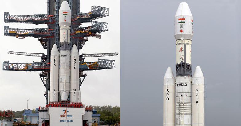
GSLV Mk-III integrated with CARE being transported to Second Launch Pad
The Indian Space Research Organisation (Isro) today successfully launched its heaviest rocket GSLV-Mk III on Thursday at 9:30 am from Sriharikota in Andhra Pradesh, marking a significant day for India's space programme. The 630-tonne 42.4 metre tall three-stage rocket blasted off with an experimental crew module that separated from the launch vehicle after reaching a sub-orbital height of around 120km and then splashed into the Andaman Sea. Naval ships waiting for the splashdown later picked up the crew module. Isro would study the flight validation of the complex atmospheric flight regime of the crew module, called LVM 3. The experiment will validate the module's ability to re-enter the earth's atmosphere with thermal resistance, parachute deployment in cluster formation, aero braking system and apex cover separation procedures. The crew module separated from the rocket as planned and made a 'soft-crash' into the Bay of Bengal some few hundred kilometres from Indira Point in the Andaman and Nicobar Islands with the help of parachutes, which was picked up by Indian Coast Guard ships. GSLV-Mk III is conceived and designed to make India fully self reliant in launching heavier communication satellites of INSAT-4 class, which weigh 4,500 to 5,000 kg. It would also enhance the capability of the country to be a competitive player in the multimillion dollar commercial launch market. While the rocket cost Isro Rs140 crore, the crew module has taken another Rs15 crore. The crew module, shaped like a giant-size cup cake - black in colour on top and brown at the bottom - weighs around four tonnes. It is about the
size of a small bedroom and can accommodate two - three people. Isro had earlier carried out a similar experiment on a smaller scale in which the module had orbited around the earth for 15 days before entering back and the current experimental flight of the LMV 3 is a further validation of Isro's human space mission capabilities. Isro chief Dr K Radhjakrishnan confirmed the successful launch of GSLV-Mk III, terming it a very significant day for India. The Isro chief congratulated his team on the highly successful launch. ''Isro has successfully carried out human crew module experiment. The module has safely splashed down into Bay of Bengal off Andaman and Nicobar Islands,'' said Radhakrishnan. "GSLV-Mark III test flight mission successful. It is a significant day in India's space history," Radhakrishnan said after the launch. Prime Minister Narendra Modi congratulated Isro for the successful launch of GSLV Mk-III. "Successful launch of GSLV-Mk III is yet another triumph of brilliance and hardwork of our scientists," the Prime Minister tweeted. GSLV-Mk III was launched using a dummy engine as Isro is still in the process of developing the cryogenic engine capable of carrying heavier payloads up to four tonnes, which is expected to be ready within two years, Radhakrishnan said. He said the cryogenic engine was being developed at the Liquid Propulsion Systems Centre at Mahendragiri in Tirunelveli district of Tamil Nadu. The GSLV-Mk III was on Thursday launched with active S200 and L110 propulsive stages and a passive cryogenic stage (C25) with dummy engine. Isro, meanwhile, is gearing up for the launch of another Indian Regional Navigational Satellites System (IRNSS), the fourth in the series of seven satellites of the IRNSS, in the first week of March next year. With the completion of the system, India would join a select group of countries having their own navigation systems. This comes less than three months after Isro successfully launched Mangalyaan – a spacecraft orbiting Mars – catapulting India to the elite club of nations that have successfully sent missions to the red planet (See: MOM Mangalyaan sends pics of Martian dust storm). Source: Article
size of a small bedroom and can accommodate two - three people. Isro had earlier carried out a similar experiment on a smaller scale in which the module had orbited around the earth for 15 days before entering back and the current experimental flight of the LMV 3 is a further validation of Isro's human space mission capabilities. Isro chief Dr K Radhjakrishnan confirmed the successful launch of GSLV-Mk III, terming it a very significant day for India. The Isro chief congratulated his team on the highly successful launch. ''Isro has successfully carried out human crew module experiment. The module has safely splashed down into Bay of Bengal off Andaman and Nicobar Islands,'' said Radhakrishnan. "GSLV-Mark III test flight mission successful. It is a significant day in India's space history," Radhakrishnan said after the launch. Prime Minister Narendra Modi congratulated Isro for the successful launch of GSLV Mk-III. "Successful launch of GSLV-Mk III is yet another triumph of brilliance and hardwork of our scientists," the Prime Minister tweeted. GSLV-Mk III was launched using a dummy engine as Isro is still in the process of developing the cryogenic engine capable of carrying heavier payloads up to four tonnes, which is expected to be ready within two years, Radhakrishnan said. He said the cryogenic engine was being developed at the Liquid Propulsion Systems Centre at Mahendragiri in Tirunelveli district of Tamil Nadu. The GSLV-Mk III was on Thursday launched with active S200 and L110 propulsive stages and a passive cryogenic stage (C25) with dummy engine. Isro, meanwhile, is gearing up for the launch of another Indian Regional Navigational Satellites System (IRNSS), the fourth in the series of seven satellites of the IRNSS, in the first week of March next year. With the completion of the system, India would join a select group of countries having their own navigation systems. This comes less than three months after Isro successfully launched Mangalyaan – a spacecraft orbiting Mars – catapulting India to the elite club of nations that have successfully sent missions to the red planet (See: MOM Mangalyaan sends pics of Martian dust storm). Source: Article


 of the GSLV-D5 mission, however, is to flight-test the rocket’s all-important third stage: the indigenously-built cryogenic upper stage (CUS). The CUS, expected to be the mainstay of future GSLV flights, replaces the Russian cryogenic engine which was used in the rocket’s earlier experimental flights. There will be a lot of crossed fingers at Sriharikota during the launch, considering the new engine had a disastrous maiden flight in April 2010, shutting down less than a second after ignition, with the rocket plunging into the sea. The GSLV’s significance lies in the fact that the future of the global satellite market lies in the field of communications. The GSAT 14 satellite piggybacking the GSLV-D5 carries six Ku-band and six extended C-band transponders to help in digital audio broadcasting and other communications across the entire
 subcontinent. Designed to last for a dozen years in its orbit, the satellite will replace the GSAT-3 (EDUSAT) which has been in orbit for 10 years. The big boosters in the GSLV series can hoist heavy communication satellites into geosynchronous orbits 36,000 km above the equator. In this position, the satellite keeps pace with Earth’s rotation and, as a result, appears stationary from the ground. This makes it easier to build simpler antennas on the ground, which do not have to track moving satellites in the sky. But powerful GSLV Mark IIIs (like the GSLV-D5) that can carry five-tonne satellites need cryogenic engines. These engines use fuels like oxygen and hydrogen in
 liquid form — stored at extremely low temperatures — to produce enormous amounts of thrust per unit mass (engineering parlance for the mass of fuel the engine requires to provide maximum thrust for a specific period such as, say, pounds of fuel per hour per pound of thrust). Rockets powered by cryogenic motors, therefore, need to carry much less fuel than would otherwise be required. Cryogenic fuels are also extremely clean as they give out only water while burning. A successful GSLV-D5 flight will make India only the sixth nation to possess this cutting edge technology, joining the United States, Russia, France, Japan and China in an elite club. India’s cryogenic
 motor development encountered some rough weather in 1993 when exaggerated US jitters — that India might utilise its space capabilities for military purposes — led to Moscow chickening out of a cryo-engine technology transfer deal with New Delhi. Of course, the real reason for guarding cryogenic engine technology so zealously probably had more to do with economics than national security. India’s arrival in the global heavy-lift launch market as a low cost launch source would have threatened the business interests of Europe, Russia, and the US. In hindsight, though, it seems to have been a disguised blessing for Indian scientists who were forced to develop
 the technology on their own. The GSLV will reduce India’s dependence on foreign launchers like the ESA’s Ariane to launch INSAT-class satellites. Isro sources speak of plans to fly two more GSLVs at six-month-intervals before using the third one for the Chandrayaan-2 Moon mission. The GSLV-Mark III is also earmarked for launching human space flights in future and building orbiting space stations. Isro has built up an impressive portfolio of comparatively cheap space products and services that are attractive to foreign space agencies that want to outsource space missions. Together with the old workhorse Polar Satellite Launch Vehicle (PSLV), the GSLV can bolster
 India’s launch capability, which already boasts 30 to 35% cheaper launches than other countries. That said, however, the space agency cannot afford to ignore the fact that other players jostling in the international space market are constantly pushing the bar still higher. For the moment, though, all eyes will be on the GSLV-D5 mission, which will determine how soon Isro can claim its rightful share of the $300 billion global space market.