 (Image: IAEA)
By Alex Hunt, World Nuclear News, in Vienna
The first results of the pioneering scientific research project launched earlier this year have catalogued microplastic particles in the sea water, sediment and animals in Antarctica.
The preliminary results were outlined during an International Atomic Energy Agency (IAEA) General Conference session focusing on the study, which is supported by Argentina and forms part of the wider IAEA NUTEC plastics initiative, which aims to use nuclear technologies to tackle plastic pollution.
Nathalie Bernard, from the IAEA Marine Environment Laboratories and University of Buenos Aires, unveiling the results, said that "sadly we have found microplastics everywhere, on every sample, every matrix". She said that the concentrations of microplastics varied by location and by day.
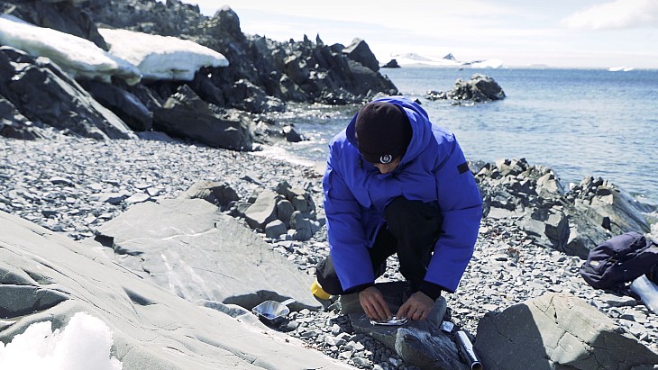
More than 250 samples were collected from the Almirante Irizer icebreaker, which sailed 27,209 kilometres over 125 days covering 84 sampling stations. Over the course of a week 166 samples were collected from Argentina's Carlini research station base as part of what was described as the first study of microplastics pollution from South America to Antarctica.
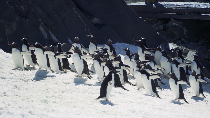
The samples were of water, of sediment and also of penguin droppings and shellfish. Bernard said: "All of these results were possible thanks to nuclear techniques, specifically vibrational microspectroscopy which allows us not only to count, but also identify polymers. We were able to analyse particles as small as 20 microns (WNN note: for comparison a human hair is about 100 microns) and this is important because we found out that almost 90% of the particles we analysed were smaller than 100 microns and ... most of the studies conducted before have focused on larger particles, larger than 300 microns, which clearly overlooks the larger majority."
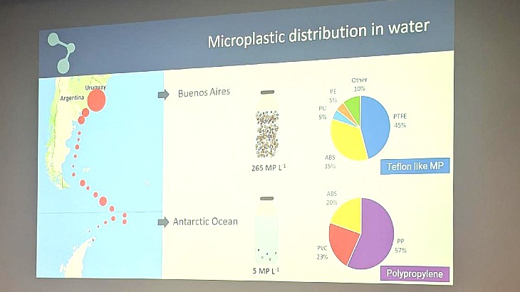
The preliminary results - with 30% of the samples analysed so far, found that in terms of distribution in water, in Buenos Aires it was 256 microplastic particles per litre, compared with 5 microplastics particles per litre in the Antarctic Ocean and 21 microplastics particles per litre at Carlini Station in the Antarctic.
The Carlini samples found 6000-15,000 microplastic particles per kilogramme of sediment, 15 microplastic particles per square metre of sand and 200-4000 microplastic particles per biological sample of shellfish or penguin droppings.
The prevalence and type of microplastics was shown to the session (Image: WNN photo/IAEA/Bernard slide)
There were 11 different types of plastics found in the samples, 62% were "Teflon-like microplastics" and 29% were polyethylene-like. Examples of the types of products using the types of plastics found included frying pans, PVC pipes and plastic drinks bottles.
The early theories about the possible sources of the pollution in Antarctica include fisheries, local human activities and global sources, via the atmosphere or ocean currents.
Bernard said that the conclusions of the preliminary study was that "we know now that microplastics are everywhere, that we can find different levels and types between the sites and that the levels in Antarctica are relatively low if we compare them with highly populated industrial zones - but they are far away from zero, which is what it was thought to be until recently in Antarctica.".
The next steps are to finalise the analysis and do extra checks before sharing the results globally and using the figures as a baseline for future surveys, to assess possible pollution sources and inform policy makers for local and global actions in line with the Antarctic Treaty.
The meeting also heard progress reports on the United Nations actions to end plastics pollution and how the NUTEC initiative can help with plastics upcycling using irradiation to allow plastic waste to not just be traditionally recycled, but also used in cement or in wood/plastic composits - one of the examples given was Argentina using radiation-modified railway sleepers from plastic waste.
Argentina's Foreign Affairs Minister Diana Mondino said that the country was one of the original signatories of the Antarctic Treaty and said: "There's growing concern in understanding the impact in the Antarctic ecosystem from plastics and microplastics." She said the results had prompted the creation of a regional group in Latin America led by Argentina to focus on the issue.
IAEA Director General Rafael Mariano Grossi said the NUTEC initiative had been well received because "we do have a serious problem with microplastics, nanoplastics and we did also have a scarcity of information, objective information". He said having the facts was important so people can take "informed decisions when it comes to the protection of this environment, which is so pristine and that we all care for".
"This is not a simple environmental endeavour that we take for the sake of knowing a little bit more - the idea is that we provide important information that is relevant for fisheries, relevant for very important economic activities in all our countries."
Australia's ambassador Ian Biggs said that Australia had a major stake in the international effort in Antarctica and he said that according to projections there could soon be a tonne of plastic in the ocean for every three tonnes of fish, saying this showed the necessity of action to tackle plastic pollution and he said Australia believed that the NUTEC programme was "making a real difference in helping countries address pressing global challenges on plastic pollution".
More than 400 samples were taken during the study (Image: Still from IAEA video)
The background
The IAEA's NUTEC plastics scheme was established in 2020 and uses a series of monitoring laboratories to use nuclear technology to sample and analyse microplastics - which are bits of plastic less than 5 millimetres in diameter - in the environment. There are more than 60 countries participating in monitoring of microplastics in the sea, and the goal is to equip more than 50 laboratories with the technology to form a global monitoring network.
The aim is to then be able to take action to bring in measures designed to reduce the sources of the pollution - at least 30 countries are involved in developing innovative recycling technology, including using irradiation to treat plastics and make them fit for reuse, or for a wider range of reuses. This process uses gamma and electron beam radiation technologies to modify certain types of plastic waste, breaking down plastic polymers judged not to be of sufficient quality into smaller components and then allowing them to be used to generate new plastic products.
The IAEA cites studies suggesting that only around 10% of plastic produced between 1950 and 2015 has been recycled, with the majority (about 60%) going to landfill, meaning action is imperative given estimates that there will be one tonne of plastic for every three tonnes of fish within a few years.
Grossi visited an IAEA mission in Antarctica in January with Argentina's president to see the start of work for the project, with the IAEA explaining that "there is still almost no information available on where and how much microplastics arrive in the Antarctic and how much is taken up by Antarctic organisms. There is also very little data existing on the types of microplastics reaching this pristine area through ocean currents, atmospheric deposition and the presence of humans in the Antarctic".It also said the "presence of microplastics can contribute to accelerating the ice-loss in Antarctica by reducing ice reflectivity, altering surface roughness, promoting microbial activity, acting as thermal insulators, and contributing to mechanical weakening of the ice structure". Scale of microplastics in Antarctic revealed in preliminary survey results